

Colle de la Noire

Description
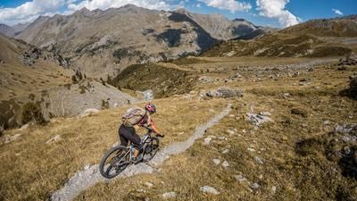
The tour starts in the Ubaye Valley, just below the Col de Vars, near the small village of Petite Serenne. Initially, the route climbs steadily uphill on asphalt as you plunge deeper into the Ubaye valley towards the north. The breathtaking mountain scenery accompanies you on this route as far as Combe Bremond. From there, the ascent switches to a single trail that is easy to ride uphill. In the area where the Ubaye stream and its tributaries flow together, the trail rides steadily uphill until the first significant pushing section at Ravin de la Salcette. Here, the bike has to be pushed briefly over a precipice or an erosion area. The ascent then continues, partly riding, partly pushing, to Lac de Longet or the final destination of the tour, the Colle de la Noire pass. Shortly before the pass, there is a particularly difficult section to overcome. As already described, the rest of the ascent can be tackled partly by pushing, partly by carrying and also by riding. Once you reach the pass or the fork in the road, the view is spectacular. Close to the national border with Italy, views open up towards Colle dell'Agnello in the north and the majestic 3000 m peaks in the south.
The descent is varied with a difficulty level of mostly S1, occasionally S2, apart from two significant pushing passages, which are considered key downhill sections. A long descent awaits you until you finally end up back on the asphalt road. Some sections run parallel to the main road on single trails before you tackle a counter-climb towards Champs Rond and a quite flowy and interesting trail that leads back to the starting point.
Note: In the upper section, there is also a short detour to Lac de Longet and the Colle del Longet pass. The route there is rather technically demanding and not flowy throughout, but very scenic. The tour is also particularly recommended outside of the main tourist season, as you will encounter almost no one and can enjoy the unspoiled nature to the full.
Map & GPX-Track
The map is only available to Ride subscribers.
The Ride-Subscription is available at ride-mtb.com/abo
.
Details of the tour
48 km
1495 m
1495 m
1490 above sea level
2916 above sea level
1 day
Saint-Paul-sur-Ubaye
Saint-Paul-sur-Ubaye
3206
limited
More information
More tours nearby


User comments (0)

About the author: Martin Depauli
Note: This content has been automatically translated from German. Please report any incorrect translations.