

Crête du Lachat

Description
You start in the center of Annecy, where you gradually gain altitude on small roads through the Bulloz district. You then cross the deeply incised river Fier on asphalt - a small detour that costs a few meters in altitude, but is the only access to the Montagne du Lachat. In the village of Villaz, turn right and tackle the serpentine ascent to the Col de Barman. The climb is mostly on asphalt, followed by a gravel road, and finally ends on a trail where you have to push in places. An alternative would be the continuous ascent to Chalet Chappuis - however, the subsequent descent to Col de Barman is rough and washed out and hardly worth it.
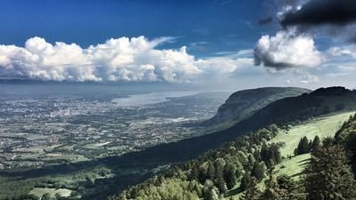
After Col de Barman, there is a tough intermediate spurt: the bike has to be pushed a good distance - e-mountain bikers have an advantage here thanks to the pushing aid. Once you reach the top, you are already on the Crête de Lachat, where the trail descent begins at a picnic spot with a fantastic view of Annecy and the wild hinterland. This starts off technically challenging (S3): steep, slippery, with loose ground - a section for experienced riders. However, the trail becomes increasingly smooth and flowy, even if some tricky sections still require concentration. Follow the ridge downhill until you reach a forest road that rides to the village of Verbin - the starting point for the next section of trail. This trail, built by mountain bikers, requires maintenance, especially in the upper section, but gains in quality as it gets longer. You finally reach the bottom of the valley and begin phase three of the tour: the return to Annecy.
First, you roll along the busy main road for a while before climbing up to Mont Rampon again at the first houses in Annecy. A short detour to the viewpoint is worthwhile: the view of the town and Lac d'Annecy is magnificent. The final descent follows below Mont Rampon. It starts technically (S2), but quickly becomes a flowing S1 trail that leads directly to the lakeshore. A jump into the crystal-clear Lac d'Annecy is the perfect end to this varied, scenic trail loop.
Note: The direct descent from Mont Rampon to Lac d'Annecy is not worthwhile and at times very technical (S5) to unrideable.
Map & GPX-Track
The map is only available to Ride subscribers.
The Ride-Subscription is available at ride-mtb.com/abo
.
Details of the tour
33 km
1300 m
1300 m
449 above sea level
1262 above sea level
Annecy
Annecy
3480
limited
More information
More tours nearby


User comments (0)

About the author: Thomas Giger
Note: This content has been automatically translated from German. Please report any incorrect translations.