

Monte Grammondo
Description
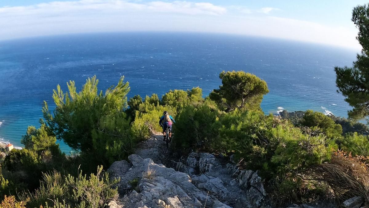
The tour starts in Ventimiglia. Ride along the main road towards Menton. In the village of Latte, turn right and from here on, the route climbs up on asphalt roads. Before Villatella, turn right and change to gravel. The route now becomes noticeably steeper and stony. The route climbs steadily on a typical Ligurian gravel road with many sections of scree. The ascent is long and tough, in the upper section the path gets worse and worse and you have to balance the bike over the scree with some effort or even push it. The climb seems endless. At the end, you reach Punta Renuit about 80 meters below the Grammondo summit. You have a colossal view of the Ligurian hinterland. If you want, you can climb the 80 meters to the summit cross on foot or carry your bike up. However, the downhill trail starts from the left at Punta Renuit. At the beginning, the trail is characterized by loose scree. The trail is not very steep. But it requires some technique to get over the rocks and scree. At Pa de la Corne, the trail becomes steeper and very thorny. A long-sleeved jersey is an advantage here, otherwise your upper arms will be scratched bloody. From now on, the trail becomes steeper and more technical, alternating between flowing and very technical passages that reach a difficulty level of S4. But for the most part, everything is easy to ride for technically experienced bikers. Especially in the lower section, things really get down to business. Rocky terrain and very steep sections once again demand maximum concentration. But you are rewarded with a sensational view of the coast. In Mortola, you return to the main road to Ventimiglia and ride back to the town center. Caution: carry plenty of water, there are no springs or refreshment stops along the route.
Map & GPX-Track
The map is only available to Ride subscribers.
The Ride-Subscription is available at ride-mtb.com/abo
.
Details of the tour
38 km
1640 m
1640 m
7 above sea level
1303 above sea level
1 day
Ventimiglia
Ventimiglia
2156
well suited
More information
More tours nearby


User comments (1)
Background to Ride MTB
Ride MTB is dedicated to mountain biking. With the maps Ride Trail Maps and Trail Books and the print magazine Ride, it has played a formative role in alpine mountain biking for many years and has shaped it like few other organizations.
In addition to the publishing business, the company is now also active in product management and operating entire mountain bike projects. These include the tourism project Ride Travel and the development of modern and authentic mountain bike offers such as the Bahnentour in Davos Klosters, Engadin St. Moritz, Lenzerheide or Aletsch, as well as the creation of multi-day tours such as the Postauto-Tour or the Hüttentour.
Ride MTB GmbH was founded in 2001 (formerly Swiss Sports Publishing GmbH) and has been owned and managed by Thomas Giger since then.
Publishing and editorial address
Ride MTB GmbH
Falladagasse 11
CH-7212 Seewis
+41 81 413 43 43
info@ride-mtb.com
Subscription management
Advertisements
Administration
Bank details: Graubündner Kantonalbank.
CHF account. IBAN: CH86 0077 4010 2958 8310 1, BIC: GRKBCH2270A
EUR account. IBAN: CH32 0077 4010 2958 8310 3, BIC: GRKBCH2270A
Company identification number (UID): CHE-102.170.292
The brains behind Ride MTB









Note: This content has been automatically translated from German. Please report any incorrect translations.
Wow - really great, wild enduro tour. However, be careful with the thorns along the way and the approach on the main road from and back to Ventimiglia. With the heavy traffic, this is probably the most dangerous part of the tour... Incidentally, you can do a great day tour from Finale by train. It takes just under 1.5 hours and the trains ride very frequently.