

Schwalbenwand

Description
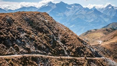
The tour starts in Thumersbach. From here, it is a relaxed ride on asphalt via Taxpoint, Hinterberg to Pointner Berg up the hamlets. From asphalt you switch to gravel and pedal on partly open terrain, partly through the forest to the Schützingalm. This hut is also a perfect place to stop for refreshments. At the Schützingalm, the route continues on asphalt for a few more meters before you push or carry your bike to the summit cross of the Schwalbenwand. A breathtaking panorama of the main Alpine ridge, the Kaprun glacier, as well as the Steinerne Meer and Hochkönig to the north, all the way to the Dachstein mountains, is on offer.
The upcoming trail descent is interesting and varied. In the upper section, the trail descends down a meadow slope, which can reach difficulty level S2 or even S3 depending on the trail conditions. You then come to another cart path, which rides very smoothly on difficulty S0 to S1 over the entire ridge up to Pointer Berg. Shortly before this, there is an idyllic forest trail, which is not too difficult. From the Pointner Berg, you briefly join the asphalt road from the ascent and from the Mitterberghof, keep taking the trail cut-offs (difficulty S1) via Reithgut down to Thumersbach.
With regard to e-mountain bikes, it should be noted that the uphill section to above the Schützingalm is perfectly feasible and you can join the trail here. The summit area is only possible to a limited extent with the help of the push function.
Tip: It is also advisable to pack your swimming gear in the summer months, as there is a well-equipped lido in Thumersbach.
Note: The route is located on Austrian territory and leads over routes that are not approved for mountain bikers. Riding this route on a mountain bike is the responsibility of each individual, in full awareness of the legal situation.
Map & GPX-Track
The map is only available to Ride subscribers.
The Ride-Subscription is available at ride-mtb.com/abo
.
Details of the tour
19 km
1180 m
1180 m
775 above sea level
1969 above sea level
1 day
Thumersbach
Thumersbach
3121
limited
More information
More tours nearby

User comments (1)

About the author: Martin Depauli
Note: This content has been automatically translated from German. Please report any incorrect translations.
Scenically beautiful tour, the trails or the cart path descent a bit boring except for the upper part of the Schwalbenwand, which is a real challenge.
I was stopped twice on the ascent because biking is not permitted.
However, I was able to continue without much discussion.