

Sissacherflue

Description
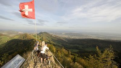
From Gelterkinden, follow the Veloland route to Sissach, but then climb up the little road to Sissacherflue. There is a phenomenal view up here, especially in foehn weather. The tour now follows the singletrails to Böckterflue and finally to Rickenbacherflue, and from there descends along the ridge to Höhi. Continue on the single trail over the Staufen to Busseregg and finally climb another 200 meters in altitude to the Farnsburg ruins. The descent back to Gelterkinden leads through the Cholacher and Homberg and is primarily on forest and access roads.
Tip:
- The route is a particularly beautiful spring tour with cherry trees in bloom
- The route can be significantly simplified if the singletrack is replaced by forest trails.
Map & GPX-Track
The map is only available to Ride subscribers.
The Ride-Subscription is available at ride-mtb.com/abo
.
Details of the tour
19 km
715 m
715 m
376 above sea level
749 above sea level
1 day
Gelterkinden
Gelterkinden
1085
limited
More tours nearby


User comments (2)

About the author: Thomas Giger
Note: This content has been automatically translated from German. Please report any incorrect translations.
I'm surprised by the direction this tour is taking. As someone from Gelterkinden, this is my backyard, and I would never ride the tour in this direction, because it simply skips the best trails down to Sissach (and I'm not talking about the Endless Trail)!
I did the tour today in nice weather and it is really beautiful, but unfortunately the GPX data is no longer correct or up to date, between Staufen and Farnsburg some sections are clearly marked "not for MTB" or even clearly forbidden. Please pay more attention to this in your proposed route, only with consideration and acceptance will we be able to use the forest together. I also enjoy riding single trails. Routes that are not suitable for MTB biking should not appear here.