

Wetterkreuz Trail - Unken

Description
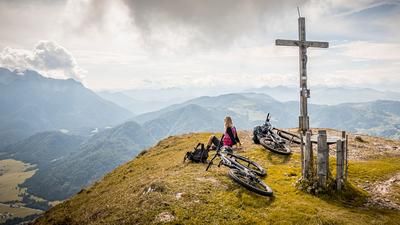
The tour starts in Unken. From here, the route climbs steadily uphill, initially on asphalt and later on gravel, past the Untere Hölzlalm and the Alpmahder Hölzlkaser until you finally reach the Wetterkreuz. A few meters down from the ridge itself to the cross and you have reached the end point of the tour. You will be rewarded after the almost 1000 meters of ascent with a breathtaking panorama with views of the Loferer Steinberge, the Hohe Tauern, the Chiemgau Alps and the surrounding mountains.
The descent is relatively selective and requires good concentration and body tension. Typical for the area is a combination of limestone, roots and earth. The difficulty level here is S2 to S3. In the middle section in particular, there are some hairpin bends with wooden steps and other fixtures to master. The trail runs directly to Unken, whereby the difficulty decreases towards the end and you ultimately return to the starting point.
Note: The route is located on Austrian territory and leads over routes that are not approved for mountain bikers. Riding this route on a mountain bike is the responsibility of each individual, in full awareness of the legal situation.
Map & GPX-Track
The map is only available to Ride subscribers.
The Ride-Subscription is available at ride-mtb.com/abo
.
Details of the tour
14 km
930 m
930 m
568 above sea level
1506 above sea level
1 day
Unken
Unken
2756
well suited
More information
More tours nearby




User comments (0)

About the author: Martin Depauli
Note: This content has been automatically translated from German. Please report any incorrect translations.