

Chasseral (Geissrücken)

Description
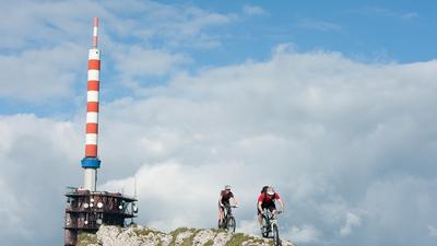
Many start the ascent to the Chasseral at the Magglingen mountain station and then cycle along the Kurhausweg and past the Twannberg to Lamboing. The ascent can also be tackled under your own steam, ideally from Biel through the Vingelzberg to Gaicht and from there via Twannberg to Lamboing. Continue parallel to the main road to Nods and then on the mountain road to the summit of the Chasseral. The tricky singletrail over the ridge begins immediately at the large transmitter antenna, which becomes smoother as the distance increases and rides to the central square. You now follow the ridge unabated, always on a singletrail until you reach the group of houses at Les Coperies. For a short distance, you roll downhill on a gravel road until a marked hiking trail branches off to the left. This is the well-known Geissrücke Trail, which rides all the way to Frinvillier. To get back to Biel/Bienne, you have to climb a few more meters to Evilard, after which the singletrail leads directly into the city center of Biel/Bienne.
Map & GPX-Track
The map is only available to Ride subscribers.
The Ride-Subscription is available at ride-mtb.com/abo
.
Details of the tour
49 km
1200 m
1645 m
433 above sea level
1575 above sea level
1 day
Biel
Biel
1002
well suited
More tours nearby


User comments (10)

About the author: Thomas Giger
Note: This content has been automatically translated from German. Please report any incorrect translations.
I rode the tour on 26.05.2022. Really beautiful scenery. With very few exceptions, the technical passages are easy to master on an enduro bike with sufficient suspension travel. I would recommend a trailbell, especially for the first part of the route up from Magglingen. That way the hikers can hear from afar that someone is coming and don't get scared (so there are no nonsensical discussions). I found the constant ups and downs after the central square a bit tedious. The exposed sections and hairpin bends described are certainly a challenge for inexperienced bikers, so it's better to descend too much than risk too much. The last ascent through the forest to Evilard is only steep for the first few meters, then it goes up relatively comfortably. I then turned right and rode about 3 km on the road to Magglingen to do the Bieltrail for dessert. In the end it was 50km and 1500hm (Garmin)
I rode the tour today 26.5.2022 (on Ascension Day). From Magglingen the first kilometers a lot of hikers - but with a friendly greeting and thanks there were no conflicts. But became more and more pleasant...
The ascent from Nods is asphalted and therefore quite comfortable. Before the transmission tower and over the ridge very great views.
The first few meters after the tower were technically challenging..., then it became quite smooth. But constant concentration is required (as well as sufficient air pressure because of the sharp stones and a functioning saddle lift because of the constant up & downs)!
Very great and varied round.
At the end, the Magglingen downhill can be added for dessert if you want to crank back up to Magglingen.
A clear tour recommendation!
We rode the tour on Sunday 17.10.2021. We deliberately started from Magglingen, as the ascent from Biel/Bienne on the road can be safely forgiven. However, the ascent to the tower on a beautiful autumn day with countless day trippers and hikers is a first challenge, as you are sometimes overtaken on the road without consideration. Once you have made the ascent, however, the "beautiful" part begins and, on a clear day, there is a magnificent view of the entire Alpine chain, which alone is worth the effort of the climb. The descent begins right next to the transmitter. However, the first 50m are difficult to ride, but after that the trail offers pretty much everything a biker's heart desires. It alternates between up and down, over pastures with different gate constructions. It is advisable to stay focused, as the typical Jura limestone does not forgive carelessness. You are also rarely alone, as there are a few hikers on nice days, but this has never been a problem. The longer the descent, the fewer hikers you meet and the terrain offers plenty of variety, from rocky to rooty, sometimes flat, sometimes steep. All in all, a highly recommended tour for experienced riders.
The tour is quite something! Especially in spring.
The ascent is worthwhile as the crossing of the ridge and subsequent single trail descent is super beautiful and varied.
The ascent back down to Magglingen is not as thrilling :-)
Watch the video to go with it......
https://youtu.be/Oa2XHjSqcxg
Very varied tour. We were there three weeks ago. If you are looking for an uphill off the beaten track, you can take a look at the following link:
https://www.komoot.de/tour/378834742?ref=itd&share_token=at7vlPiiWOwv2I…
The trail to Frinviller is quite challenging in at least one place (S3) and there are lots of hairpin bends (in my opinion, it's not absolutely necessary to move the rear wheel, but it doesn't hurt to keep the flow going) and steps, otherwise everything is between S0-S2 and very varied. At the end, we rode through the Bikepark Biel, which was a really cool way to finish.
Rigorous but beautiful tour, especially in spring!
https://youtu.be/Oa2XHjSqcxg
But also in the rain in fall :-)
https://youtu.be/yXtHtA03hz4
Super round
You have to do it once.
Here is a short video
https://www.youtube.com/watch?v=VMS3yCc_Byo&feature=youtu.be
Just under 60km and 2000 vertical meters from Biel without a railroad line. Beautiful tour, the descent to Frinwillier is a little exposed in places and better to ride in dry conditions.
Great tour, although the ascent from Nods at the latest is only along the asphalt road. The first section from the antenna is very technical but then becomes increasingly smooth.
You can avoid the asphalted road from Nods to the antenna by going straight ahead in the first left-hand bend at the start of Nods. Then keep going up and around to the left via les Cordonniers, about 50m below the sharp right-hand bend back onto the pass road. In the bend, go straight on to the Mét.de lÌsle. Pass in front of the house then steeply uphill. At the top, turn left down a path towards Combe Biosse. Turn half right across the pasture to the Mét. de Freinisberg. This is how you reach the hill and the path to the hotel and the antenna via the rear pass road.