

Palnock – Süd

Description
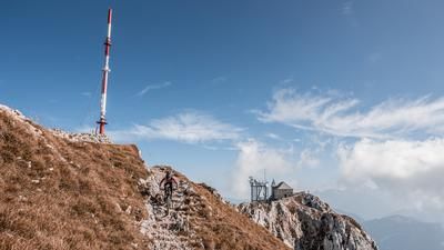
The tour begins in Weissenstein. In this small village, after a few turns of the pedals, you’ll hit a gravel road that eventually leads back onto asphalt toward Fresach. Climbing the southern slopes through Fresach, you’ll ride steadily upward for what feels like an eternity, crossing below the Palnock and passing the Alpengasthof Walder mountain inn. Finally, you switch back to gravel and reach the saddle, with the last few meters of elevation gain gently winding along the ridge across meadow slopes until you reach the summit at 1,901 meters above sea level. The view to the south toward Dobratsch and the Austrian-Italian border, as well as toward Lake Millstatt and to the north, is extremely impressive on a clear day.
The descent heads south and features varying levels of difficulty. For the most part, the difficulty level is S2, though there are a few key sections that raise the technical demands. Riders should possess technical skills between levels S2 and S3 to fully enjoy this relatively long trail. A stop at the Alpengasthof Walder is recommended before continuing steadily downhill back to the starting point in Weissenstein.
Note: The route is located on Austrian territory and leads over routes that are not approved for mountain bikers. Riding this route on a mountain bike is the responsibility of each individual, in full awareness of the legal situation.
Map & GPX-Track
The map is only available to Ride subscribers.
The Ride-Subscription is available at ride-mtb.com/abo
.
Details of the tour
24 km
1390 m
1390 m
533 above sea level
1873 above sea level
1 day
Weißenstein
Weißenstein
3683
well suited
More information
More tours nearby


User comments (0)

About the author: Martin Depauli
Note: This content has been automatically translated from German. Please report any incorrect translations.