

Pico de la Bandera

Description
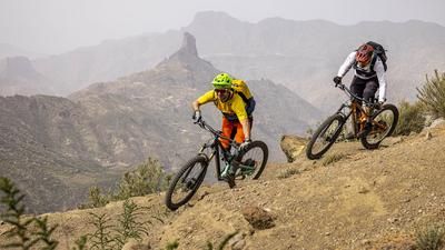
The starting point for this top-class tour is Cruz de Tejeda in the heart of Gran Canaria. A section of asphalt ascent to a viewpoint serves as a warm-up phase, followed by a few meters of pushing to finally turn into the super trail to Artenara. This always follows the steep rocky slope that rides down into the high valley of Tejeda. The trail is exposed in places, but is flowy and super fun to ride throughout. In Artenara, there is a counter-climb on asphalt before heading into the next singletrail on the hill. This leads down a racy descent through open pine forest to the road, which you then follow parallel to on trails heading west. A short pushing section is also part of the program so that you can head for the next flowing trail. This is how you reach the Degollada Honda pass and the tour would already be a great route up to this point. But the highlight is still to come!
To complete the long descent to Agaete, you now climb up to the Pico de la Bandera (1440 meters above sea level) in the middle of the Tamadaba Nature Park. Fit mountain bikers manage to ride all the way up, others push from time to time. There are a total of 150 meters in altitude before the descent over the northern flanks of the mountain begins. The first part is so flowy that you could almost get bored. You whizz through the open pine forest at full speed until suddenly the sea is visible far below on the left and you can see how steep the terrain is. This becomes apparent a little later when the path switches to serpentine mode and rides steeply down the mountain flank. This spectacular section is at S3 level throughout with S4 sections and is the most difficult section of the tour. It descends in this manner to a saddle. Keep left here, the trail now flows along the steep, lush green meadow terrain - a phenomenal section! You reach the ridge above Agaete and really pick up the pace again. The last few meters are a bit rougher, but lead down to the first houses of Agaete.
Conclusion: One of the most varied, flowing and spectacular mountain bike routes in the world. No joke! Please note: There are no refreshment facilities along the route. The return trip to Cruz de Tejeda is either by bike shuttle or cab (the ride from Agaete to Cruz de Tejeda costs around 50 euros and takes an hour).
Map & GPX-Track
The map is only available to Ride subscribers.
The Ride-Subscription is available at ride-mtb.com/abo
.
Details of the tour
31 km
740 m
2250 m
14 above sea level
1738 above sea level
1 day
Cruz de Tejeda
Agaete
2675
well suited
More information
several possibilities in Artenara
More tours nearby



User comments (2)

About the author: Thomas Giger
Note: This content has been automatically translated from German. Please report any incorrect translations.
Really very impressive tour. The descent is crisp and unfortunately logistically a little awkward with the return journey.
Still worthwhile, thank you very much!
Hello Michael,
we also want to ride the route in February. How did you do the return journey?
We have to go to Maspalomas.
Greetings Christoph