

Chamonix Gondeltour

Description
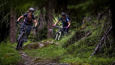
Section 1: The tour has a veritable cold start: after the gondola ride up to Planpraz, it's straight downhill. Rumpy and in serpentine mode, you head straight down to Chamonix. The former road is now a single trail, sometimes flowing and fast, but then challenging again. The upper part of the descent is rocky, further down in the forest it is rougher but much smoother. This is how you circle down to the valley station. Difficulty of the first descent: S2 with S3 sections.
Section 2: Ride up to Planpraz again, but the descent now leads down the other side of the gondola. To do this, you first climb a few meters on the gravel road before turning into the Sentier des Gardes a little later. The path hugs the high alpine mountainside and is surprisingly smooth to ride. Be sure to stop here every now and then, the view of Mont Blanc behind you is phenomenal! Finally, you enter the forest and follow the official bike route (Charlanon). This is crisp and challenging, steep and winding. Follow the route until it turns left at an altitude of 1565 meters above sea level. Now head straight ahead on the trail. This narrow path winds almost horizontally through the steep terrain and in some places the bike has to be pushed briefly. It rides almost flat through the terrain for quite a long time, but then suddenly drops off and becomes great fun. This is how you reach the Planpraz valley station again. Difficulty of the second descent: initially S2, then S3 throughout with S4 sections.
Section 3: The third and final ascent to Planpraz. The third descent is identical to the second up to the left-hand serpentine where you previously rode straight ahead. In this case, you now follow the signposted "Charlanon" mountain bike route unabated. In switchback mode, you reach a gravel road. Here, the official route would now ride back to Chamonix on the right. In this case, however, you follow the trail straight ahead and reach the village of La Praz and the valley station of the Flégère gondola lift quickly and smoothly. Difficulty of the third descent: initially S2, then S3 throughout.
Section 4: From the mountain station, you descend directly along a barely maintained mountain bike trail, which is still easy to ride. In this way, you cycle through the forest with a constant view of Mont Blanc. Finally, you reach a gravel road, follow it for a few meters and then turn left into the final part of the descent. The path winds its way down to the valley floor in a flowing, winding descent. Difficulty of the fourth descent: S2.
Section 5: The last descent starts at the top station of the Flégère gondola lift. You roll down a few meters on a gravel road until the trail branches off to the left at the edge of the forest. This is challenging but easy to ride. Rock slabs and hairpin bends require concentration. You descend to a small forest clearing with a fork in the road. Now it gets steep! Switchback after switchback, the path winds steeply downhill; turning the rear wheel is a practical skill here. This section really puts your riding technique to the test again, but good mountain bikers will really enjoy this final section. In this way, you reach the Petit Balcon Sud and roll along this flowing and wide path with a few short counter-climbs back to Le Praz or along the River Arve back to Chamonix. Difficulty of the fifth descent: S3 with S4 sections.
Note: The tour can only be ridden at the beginning of September because the Planpraz cable car only takes mountain bikers all day in September but is usually only in summer operation for the first week of September. In July and August, mountain bikes can only be taken from 3 p.m.
Map & GPX-Track
The map is only available to Ride subscribers.
The Ride-Subscription is available at ride-mtb.com/abo
.
Details of the tour
32 km
180 m
4500 m
1060 above sea level
2067 above sea level
1 day
Chamonix
Chamonix
2561
well suited
More information
More tours nearby




User comments (0)

About the author: Thomas Giger
Note: This content has been automatically translated from German. Please report any incorrect translations.