

Monte Mia

Description
The starting point is the village of Stupizza. The route starts on asphalt along the border road via Stupizza to Slovenia. You pedal idyllically along the Nadiža until you reach Robič. Before Robič, the valley opens up wide and the route then continues along the watercourse on a mix of cart tracks, trail sections and forest roads to Podbela. From Podbela, the route continues on asphalt to Kamp Lebanc and in a similar manner past countless bathing bays at the famous Napoleonov Most bridge. Afterwards, the route climbs steadily uphill on gravel at a moderate gradient to the summit of Monte Mia. At the end, the bike has to be pushed, or e-bikers in good physical condition and with good riding technique can still pedal a few sections here. Monte Mia itself is a typical pre-Alpine mountain. The summit cross lies a little lower to the south, is small and offers a good panorama.
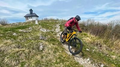
The trail descent is also more than usable. The upper section is typical of the Soča Valley and Alpine foothills. Beech forests combined with limestone and karst rocks don't really make it easy. Now S2, S3 level, the trail continues to Ricovero Casera Monte Mia. Continue on the Cai 754 towards Bocca di Pradolino, the small pass crossing. Here you then head towards Stupizza and have a long downhill with varying degrees of difficulty. Partly very flowy, partly also very blocked combined with some rocky passages, it ends with a few steps back to Stupizza.
Map & GPX-Track
The map is only available to Ride subscribers.
The Ride-Subscription is available at ride-mtb.com/abo
.
Details of the tour
33 km
1120 m
1120 m
204 above sea level
1202 above sea level
1 day
Stupizza
Stupizza
2868
limited
More information
More tours nearby





User comments (0)

About the author: Martin Depauli
Note: This content has been automatically translated from German. Please report any incorrect translations.