

Napf (Lützelflüh)

Description
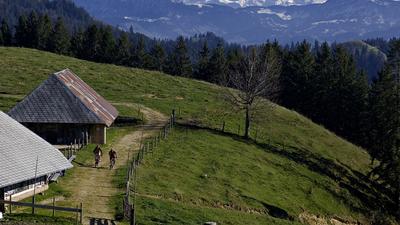
From Lützeflüh, you take the country road to Sumiswald and then climb up along the ridge of the Heimisbachtal valley to Senggenberg. The route is now somewhat flatter up to Lüdernalp, after which it is a mix of trails, gravel paths, ascents and descents past the Geissgratflue and Hochänzi to Niederenzi. This is followed by another fun section of single trail until the last section up to Napf has to be tackled on foot. But then it's done and a stop at the inn is well deserved. The return journey then follows the same route to Lüdernalp. Where it was fun before, it's now sweaty business - and vice versa. At Lüdernalp, the paths separate and you keep left towards Tällihüttli. Staying at the same altitude, the route leads to Schlossschnubel and down to Lützelfüh via Ramisberg and Ramseiberg.
Map & GPX-Track
The map is only available to Ride subscribers.
The Ride-Subscription is available at ride-mtb.com/abo
.
Details of the tour
54 km
1555 m
1555 m
582 above sea level
1385 above sea level
1 day
Lützelflüh-Goldbach
Lützelflüh-Goldbach
1470
limited
More tours nearby




User comments (2)

About the author: Thomas Giger
Note: This content has been automatically translated from German. Please report any incorrect translations.
A tip, especially for e-bikers. The original route led up a steep Nagelfluh, where you have to push or carry. Alternatively, ride in the direction of "Krähenbühlalp" until just before the altitude indication "1255", where you turn right and ride back to Hochänzi on the cantonal border.
I rode the tour on a rainy Monday in June. If you want to save yourself a few kilometers of pedaling, you can also start the tour directly from Lüdernalp. From there, it's a wonderful scenic route. Unfortunately, there is very little flow as it is a constant up and down. But the trails are a real treat. I would especially like to mention the small self-service café at Hochänzi, where I was able to fortify myself with lots of coffee and cake after a heavy downpour. All in all, a worthwhile excursion!