

Brgud - Mosčenice

Description
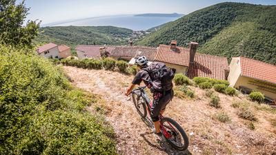
The starting point is the tourist town of Moščenička Draga. From Moščenička Draga, pedal steadily uphill along the asphalt road towards Mosčenice. The small village of Mosčenice is idyllic and mystical, built over the centuries on the edge of the mountain directly on Kvarana Bay and boasts a beautiful old town. Past this beautiful place, the route initially follows a forest road on asphalt and later on relatively rough gravel to Prelas Bodaj. From this point, the route continues uphill for a few meters before finally reaching the highest point of the tour at 907 m above sea level at Brgud. With good visibility, the islands of Cres, Krk and the hinterland of Istria are clearly visible. The flora and fauna here is also completely in sync. Eagles are also not uncommon, taking advantage of the thermals on the slopes. From the summit itself, the route continues on difficulty S1, S2 combined to the ascent variant of the forest road. There are a few tricky sections embedded in the trail, but these can only be assessed at certain points. It should also be noted that in the summer months, the high temperatures and heavy vegetation can cause the trail to become somewhat obstructed, but it is easily recognizable in the rest of the year. In the same manner, or on a historical path, the route leads towards Mihani. Concentration is required, as there are many loose stones along the way and it is easy to lose your bike. In Marici, you pass the chapel and take a wonderful mule track towards Mosčenice. The place, which is known from the uphill, can now be descended in 2 variants. Southwards over what feels like 1000 steps to the bay of Moščenička Draga, or via a historic path directly in the gorge of Moščenička Draga. The path then leads below the coastal road of Kvarana Bay and finally ends on a staircase that rides directly to the bay or to Moščenička Draga.
Map & GPX-Track
The map is only available to Ride subscribers.
The Ride-Subscription is available at ride-mtb.com/abo
.
Details of the tour
23 km
900 m
900 m
3 above sea level
889 above sea level
1 day
Mošćenice
Mošćenice
2717
well suited
More tours nearby


User comments (0)

About the author: Martin Depauli
Note: This content has been automatically translated from German. Please report any incorrect translations.