

La Valmortelle

Description
From Moûtiers, roll under the N90 road onto the D117. The main road towards Val Thorens is busy but also wide and has a pleasant gradient. After 8.5 kilometers, you leave the D117 and ride through Fontaine-le-Puits to the upper edge of the village, where the route joins a gravel path. This now climbs a little more steeply and leads through the forest to Le Puits. Here you turn left onto the Route du Col and stay on it for another 1.4 kilometers. Where the road winds up to the pass on the left, the route continues straight ahead, slightly down and up twice. The trail entrance is about halfway up the second ascent.
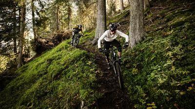
The descent begins steeply and rapidly before taking a sharp right where the trail rides along the slope. This is followed by the first section with hairpin bends, then an intermediate section on a wider hiking trail with a short counter-climb to the north. The route then descends again, and it is easy to forget the non-obvious junction that leads to a trail on the left. Although it is not crucial for the route, this small "detour" is perfect for getting over the wide path and round onto the actual single trail. On this trail, bend after bend follow each other, sometimes narrow, sometimes more open, sometimes steeper, but mostly always flowing. After a short interruption on the forest road, the bend-fest continues until you reach the main road D117 via a steep descent. Be careful, this section must be mastered slowly and in a controlled manner, otherwise you will end up directly on the road. If in doubt, it is better to descend here. Now cross the main road and return to the trail, where the tour can be casually rolled out. The next junction is ignored on this last section, and after a few minutes you end up in a small industrial district in Salins-Fontaine, which you leave to the south on the D915 and roll back to Moûtiers.
Map & GPX-Track
The map is only available to Ride subscribers.
The Ride-Subscription is available at ride-mtb.com/abo
.
Details of the tour
19 km
850 m
850 m
475 above sea level
1362 above sea level
1 day
Moûtiers
Moûtiers
2599
well suited
More tours nearby



User comments (0)

About the author: Balz Weber
Note: This content has been automatically translated from German. Please report any incorrect translations.