

La Talvena

Description
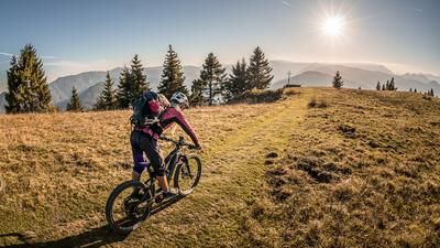
The route starts just north of downtown Belluno. From there, it’s a relatively easy ride on paved roads toward Bolzano Bellunese, followed by a stretch with moderate to gentle gradients toward Pian di Neve. At Casere Stalon, the trail switches to a singletrack, and from there on, you’ll only be pedaling for a few meters. Most of the way here is covered by pushing or carrying the bike up to Ristoro Matteo Da Rold. The view from an altitude of just under 1,300 meters above sea level is extremely impressive. The Piave River and the Italian Pre-Alps, in particular, offer a perfect view here in spring and late fall when humidity is low. The final meters to the summit are still rideable before setting up a mountain bike depot at the pre-summit and, depending on your motivation, tackling the actual summit on foot. It is not possible to take the mountain bike all the way to the cross itself. The highest point of the ride offers a breathtaking view from Monte Serva toward Pasubio, the Mediterranean Sea, and the Italian Pre-Alps to the south.
Then the descent begins. Generally rated S1 and S2 in difficulty, you navigate several hairpin turns very smoothly and consistently down into the valley. A solid hairpin turn technique is advantageous in some sections, as the turns are quite tight. The trail becomes increasingly smooth as it progresses and eventually leads all the way to Schirada. You briefly take the access road and then head straight into the next trail shortcut toward Torrente Medon. From there, you wind your way along side roads, trail sections, and cart tracks toward the Peace Monument. Along the way, you can incorporate a few interesting trail sections toward Belluno, where the loop finally closes.
Note: This ride should be undertaken in dry conditions, as the trail runs entirely on dirt in some sections and erosion damage can otherwise become excessive. Additionally, it is recommended not to ride these sections in late fall or late winter, as the ground becomes extremely slippery when the soil is saturated with moisture.
Map & GPX-Track
The map is only available to Ride subscribers.
The Ride-Subscription is available at ride-mtb.com/abo
.
Details of the tour
22 km
1140 m
1140 m
397 above sea level
1442 above sea level
1 day
Belluno
Belluno
3706
not suitable
More information
More tours nearby




User comments (0)

About the author: Martin Depauli
Note: This content has been automatically translated from German. Please report any incorrect translations.