

Passo di Pietena - Passo Le Vette Grandi

Description
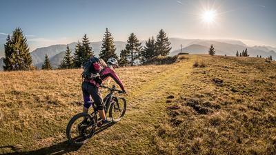
The starting point of the tour is the Passo Croce d'Aune at over 1000 meters above sea level. From here, the route climbs a few meters on asphalt before continuing uphill on a former military road from the First World War. A fabulous structure that was built here in the Belluno Dolomites. Constant gradient, extreme routing and a masterpiece of engineering for the conditions at the time. This road rides with fabulous views up to the Passo Le Vette Grandi (1994 meters above sea level). From here, the route descends a few meters before taking Sentiero 801 and following it to the Passo di Pietena and the former Postazione Partigiana military installations. The uphill section can still be pedaled in places, but the remaining sections have to be pushed. Once you reach the saddle, you are surrounded by the Belluno Dolomites and in the heart of the national park. Absolute tranquillity, epic views and unspoilt flora and fauna greet mountain bikers here.
The downhill is just as welcome. Initially on the same route as the uphill, the route leads back to Passo Le Vette Grandi on difficulty levels S1 to S2. From Passo Le Vette Grandi, the difficulty changes abruptly. Between S2 and S4, you hit the trail cut-offs here. If these are too difficult, you have the option of using the ascent road as a downhill. This is much easier, but no less spectacular. The route then continues below Monte Masieron and above Colle dei Cavái down a fantastic trail from S2 to S3 level. This ends above Passo Croce d'Aune and thus concludes the tour.
Note: If you start the tour from Pedavena, you can continue using the downhill section of the "Passo Le Vette Grandi - Passo Croce d'Aune" tour from Passo Croce d'Aune.
Map & GPX-Track
The map is only available to Ride subscribers.
The Ride-Subscription is available at ride-mtb.com/abo
.
Details of the tour
22 km
1180 m
1180 m
1010 above sea level
2087 above sea level
1 day
Passo Croce d'Aune
Passo Croce d'Aune
2722
well suited
More tours nearby



User comments (0)

About the author: Martin Depauli
Note: This content has been automatically translated from German. Please report any incorrect translations.