

Tolzer

Description
The ride starts in Greifenburg. From here, the route begins on paved roads on the south side, climbing steadily uphill before arriving at the Gnoppnitzalm after a very long uphill stretch. For the most part, the ascent follows a superbly maintained road with moderate to gentle gradients. A few meters further on, past the Gaugen alpine hut to the ski lift station, you can still pedal forward before you have to push or carry your mountain bike further and further uphill.
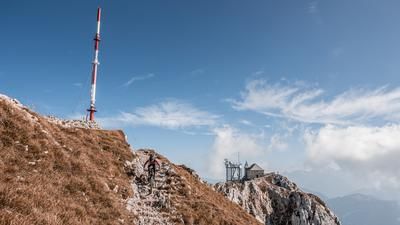
At this pace, you head toward the Gnoppnitztörl before keeping to the right and climbing to the pre-summit toward the Tolzer. Alternatively, the uphill section can be extended here. However, you’ll need to assess how well you can handle the sections where you have to push or carry your bike along the ridge. The Tolzer itself offers an exceptionally impressive view and is particularly captivating in the fall, when thick fog lies in the Drau Valley.
The descent initially follows the ascent route and, in the upper section up to the T-bar lift station, alternates between S3 and S2 sections, with the latter predominating. From the alpine huts or lodgings, the route follows an old pack trail with a difficulty rating of S1 to S2, steadily descending back to the ascent route. You then cross the south side of the mountain with a slight uphill section and reach the next trail shortcut or mule trail in the Orter/Rottenstein area. This leads directly to the Bergfriede campground and subsequently to Steinfeld. From Steinfeld, the route briefly follows the main road and later side roads back to the starting point.
Map & GPX-Track
The map is only available to Ride subscribers.
The Ride-Subscription is available at ride-mtb.com/abo
.
Details of the tour
34 km
1760 m
1760 m
581 above sea level
2091 above sea level
1 day
Greifenburg
Greifenburg
3742
limited
More information
More tours nearby


User comments (0)

About the author: Martin Depauli
Note: This content has been automatically translated from German. Please report any incorrect translations.