

Lauchflue

Description
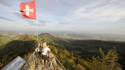
It is almost exactly 500 meters in altitude from Oberdorf in the canton of Basel-Land up to the Chilchzimmersattel. You overcome this on the little road at the edge of the Dielenberg forest, add a short singletrail descent to Walibach and then climb north of the Lauchflue and Geissflue via Obere Belchen to the Chilchzimmersattel. The ascent is almost complete here, but there is now a constant up-and-down over first-class singletrails as far as the Lauchflue. From the bunker on the Lauchflue, there is an excellent view of the Solothurn and Basel Jura mountains, with the Vosges and Black Forest visible in the background. The following descent is technical at first, but then quickly becomes smoother and leads downhill to Sennenhöchi. Opposite the forest clearing, the singletrail continues downhill to Fueterstig and then circles the Edlisberg on the southern side at the edge of the village of Oberdorf.
Alternatives: From the Lauchflue, always follow the ridge path to the Waldenburg ruins. Beware, this path is very challenging!
Map & GPX-Track
The map is only available to Ride subscribers.
The Ride-Subscription is available at ride-mtb.com/abo
.
Details of the tour
18 km
730 m
730 m
491 above sea level
1020 above sea level
1 day
Oberdorf BL
Oberdorf BL
1091
well suited
More tours nearby


User comments (2)

About the author: Thomas Giger
Note: This content has been automatically translated from German. Please report any incorrect translations.
Trail section from Rehhag (1007hm) down to Sennhöchi is closed!
Tour in the Bunkertrail section is very challenging, even with e-bikes. Many places to push.
The singletrail up to Lauchflue is quite challenging and certainly a treat for technicians (very bumpy and rooted). Unfortunately, there are a lot of fence gates on this stretch which reduce the flow a little. I would rate the level of difficulty as S2-S3. The ridge path to the ruins is really very demanding where you have to walk a lot (up to S4). However, the trail from Rehag is very cool and smooth to ride. I liked the section from Sennhöchi the best. All in all, a beautiful but sometimes very challenging trail descent to Waldenburg.