

Rifugio Puez

Description
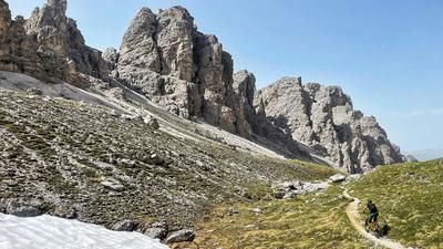
In sporting terms, the tour to the Rifugio Puez is not a masterpiece, as a large part of the altitude difference is covered by the Dantercepies cable car. If you set off outside of the cable car operating times (which is recommended due to the significantly lower number of hikers), you should ideally take a shuttle up to the Gardena Pass and then tackle the ascent to the Jimmy hut under your own steam. The hut is also the starting point of the carrying passage up to Furcela de Cir through the middle of the rock towers. At the top of the pass, however, the ascent is not quite finished yet. There's a short, crisp descent, then an easy traverse, before finally shouldering the bike again up to the Jeuf de Crespeina. That's it in terms of fitness, from now on the focus is on riding technique. The first part of the descent is very demanding, slippery and winding - the majority of mountain bikers push a considerable amount here. As soon as you reach the Crespeina plateau just above the small lake, the fun begins. A wonderful path winds its way through the plateau, even if a short pushing section breaks up the flow from time to time. This is how you reach the Furcela de Ciampei - from here you can expect many hikers coming up from the Alta Badia region with the Rifugio Puez as their destination. This is also our destination and a good opportunity for refreshments. Because another challenge awaits us: Sentiero 16 down into Val Longia. This begins after a first-class high-level trail and the first section is a massacre of steps. As soon as this section is completed, the trail becomes rideable, albeit still a technical challenge. In this way, you wind your way towards the valley floor. The trail becomes increasingly flowy until it rides along the valley floor as a wide, flowing trail back to Selva Gardena.
Map & GPX-Track
The map is only available to Ride subscribers.
The Ride-Subscription is available at ride-mtb.com/abo
.
Details of the tour
16 km
435 m
1180 m
1544 above sea level
2513 above sea level
1 day
Wolkenstein
Wolkenstein
2008
not suitable
More information
No bike shops are registered for this region. Registration as a partner takes place here.
More tours nearby







User comments (1)

About the author: Thomas Giger
Note: This content has been automatically translated from German. Please report any incorrect translations.
Unfortunately, as with most tours in Val Gardena, there are now many sections on this tour where biking is prohibited. You can’t even get to the Jimmy Hut. In Val Gardena, the only routes still open to bikes are the official trails near the mountain railways; everything else that would qualify as a singletrack is off-limits to bikes. What a shame!