

Ochsenlenke

Description
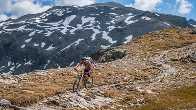
The route starts at the Brunnalmbahn lift parking lot in the St. Jakob ski center in the Defereggental valley. From here, you ride steadily uphill along the classic forest road and farm road toward the Mooserberg mountain station of the Brunnalmbahn. From there, the route leads past the station to just below the Ochsenlacke reservoir. The view to the north toward the main Alpine ridge, with the massive 3,000-meter peaks in sight, is truly impressive. The uphill climb essentially ends just below the reservoir. Consequently, you’ll have to push and carry your mountain bike from here on. First, you tackle a relatively long traverse before subsequently reaching the Ochsenlenke at 2,744 meters above sea level via the side trail. At the highest point of the tour, in the saddle between the Wagenstein and the Grosses Degenhorn, you can enjoy a very impressive view to the south and north in a high-alpine setting.
Then the descent begins. With difficulty levels ranging from S1 to S3, the route offers a bit of everything, though most sections settle between S2 and S3. This is followed by another traverse, where short sections of pushing must be factored in, before you enter the next trail section below the reservoir. Very alpine and dotted with a few hairpin turns, the route winds down along the steep rock edge or rocky outcrop toward the Brunnalmbahn. The view at this point is legendary, but full attention should be paid to the trail. You continue across the ski area toward the Weissspitzbahn and reach the next trail section, which can be ridden relatively smoothly at difficulty level S2 toward Drauggeralm. This is also a good spot to take a break. Afterward, you ride briefly along a cart track before the grand trail finale begins, with an old cart track or mule trail rated S1 to S2+ leading down to the starting point.
In summary, this is a very inviting ride that, due to its high altitude, makes for a perfect loop—especially in summer when temperatures are high.
Note: The route is located on Austrian territory and leads over routes that are not approved for mountain bikers. Riding this route on a mountain bike is the responsibility of each individual, in full awareness of the legal situation.
Map & GPX-Track
The map is only available to Ride subscribers.
The Ride-Subscription is available at ride-mtb.com/abo
.
Details of the tour
23 km
1310 m
1310 m
1416 above sea level
2713 above sea level
1 day
St. Jakob im Defereggental
St. Jakob im Defereggental
3682
not suitable
More tours nearby


User comments (0)

About the author: Martin Depauli
Note: This content has been automatically translated from German. Please report any incorrect translations.