

Kalser Höhe

Description
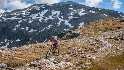
The tour starts in the mystically situated Kals am Großglockner, Austria's highest mountain, and initially rides on asphalt towards Temblerhof. From there, you follow the official Gornerberg Weg cycle route through dense stone pine forests steadily upwards to the Kals middle station. This is where the more challenging part of the route begins: the narrow mountain path, which is signposted as a single trail and has a width of around 1.5 meters, continues to the Kals-Matreier-Törl Haus. The uphill over the Kals-Matreier-Törl trail is mostly easy to pedal, even for biobikers.
At the Kals-Matreier-Törl Haus, the possibility of pedaling ends and the route continues upwards over the ridge by pushing. Not only do you gain altitude meters, but also breathtaking views. The highest point of the tour is reached at the Kalser Höhe at 2434 meters, where you can take the time to marvel at the striking mountains in the surrounding area. The view of the Grossglockner, which you could already see during the ascent, is particularly spectacular.
The trail descent that follows is also one of the highlights. In the upper section between difficulty levels S1 and S2, the grippy gravel path rides steadily down to the Kals-Matreier-Törl Haus, where you can enjoy a leisurely stop for refreshments. Then follow the Kals-Matreier-Törl Trail downwards, starting with a section of difficulty level S1. At the Kals middle station, the surface briefly changes to gravel before you reach the Gornerwald Trail. This is a perfectly laid out trail, but it rides like a natural single trail, complete with countless hairpin bends, roots, some jumps and steep turns, which offers a perfect riding experience.
To cool down, there is a small flow jump line at the end before you arrive at the Temblerhof. You then surf down a meadow path and follow a small trail section over the Kalser Bach stream until the loop closes. For those who need a shuttle, the gondola lift from Kals am Großglockner to the Kals middle station is a useful option.
Note: The route is located on Austrian territory and leads over routes that are not approved for mountain bikers. Riding this route on a mountain bike is the responsibility of each individual, in full awareness of the legal situation.
Map & GPX-Track
The map is only available to Ride subscribers.
The Ride-Subscription is available at ride-mtb.com/abo
.
Details of the tour
18 km
1055 m
1055 m
1315 above sea level
2373 above sea level
Kals am Großglockner
Kals am Großglockner
3277
limited
More information
More tours nearby


User comments (0)

About the author: Martin Depauli
Note: This content has been automatically translated from German. Please report any incorrect translations.