

Weißer Knoten

Description
The tour starts in Lesach, below the Lesach Valley and close to Kals am Großglockner. The first section rides along a stream on the official cycle route to Kals. From here, the route continues on gravel via the feeder road to the Lucknerhaus and steadily uphill along the official cycle route. This section of the route not only offers numerous meters of elevation gain, but also impressive panoramic views of the surrounding mountains.
Shortly before the Lucknerhaus, the route turns right. A moderately steep forest road continues uphill and increasingly turns into a cart track, which eventually turns into a path towards the Glorerhütte. Some sections are still pedalable for biobikers, while e-bikers can easily manage the entire ascent to the Glorerhütte (2651 meters above sea level).
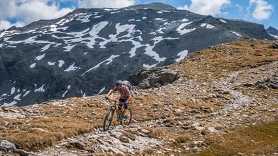
On arrival at the Glorerhütte, the trail continues to the left towards the Weißer Knoten and Sattel, with breathtaking views of the Grossglockner. The route also marks the start of the Hohe Tauern National Park. The trail runs along the border up to the Weißer Knoten, with some sections having to be pushed and others carried. At the summit (almost 3000 meters above sea level), an incomparable panorama awaits: the Grossglockner and the Grossvenediger stand majestically in view, while the autumnal landscape with dyed soil and larch forests provides an impressive backdrop.
The descent begins directly from the summit with difficulty levels S2 to S3 as well as 2 significant key sections with S4. The trail is exposed in places, but offers magnificent views throughout. From the saddle, the route rides relatively smoothly (S2) back to the Glorerhütte. From the hut, the route continues at S1 level via a trail down to the gravel road, which has to be descended a few meters in altitude.
From the Lucknerhaus, there are trail cut-offs that are not too difficult, with the exception of a serpentine climb above Kals am Großglockner. A sure instinct and hairpin bend technique are required here. After a short passage on the main road, a counter-climb of around 100 meters in altitude follows, which rides to the valley circuit. This section is an absolute highlight: the trail runs on a mule track along a ridge, with varied up and down passages in cross-country style. The trail ends above Pradell, from where a final flowing trail section leads back to Lesach.
Conclusion: This tour is an impressive alpine tour that offers outstanding panoramas and technical challenges. Although some sections on the forest road lose trail quality, the magnificent views and varied trails more than make up for this.
For e-bikers, the route to the Glorerhütte is easily doable, although a short carrying section of around 100 meters in altitude is required before the summit.
Note: The route is located on Austrian territory and leads over routes that are not approved for mountain bikers. Riding this route on a mountain bike is the responsibility of each individual, in full awareness of the legal situation.
Map & GPX-Track
The map is only available to Ride subscribers.
The Ride-Subscription is available at ride-mtb.com/abo
.
Details of the tour
31 km
1665 m
1665 m
1240 above sea level
2804 above sea level
Lesach
Lesach
3378
limited
More information
More tours nearby


User comments (0)

About the author: Martin Depauli
Note: This content has been automatically translated from German. Please report any incorrect translations.