

Muhs Panoramaweg

Description
The start is just outside Prägraten, directly on the Isel. From here, a gravel path with a predominantly medium to moderate gradient rides steadily uphill. After a short time, you reach the panoramic road, which continues further and further into the Lasnitzen valley. The Lasnitzenhütte hut soon appears on the right-hand side - an ideal opportunity for a leisurely stop with a view of the surrounding mountains.
From the hut, the terrain becomes more challenging: the mountain bike now has to be pushed in places and sometimes pedaled with the last of your strength. The trail continues into the Michltal valley, where an impressive high mountain panorama opens up, reminiscent of the wild landscapes of the Western Alps. At around 2150 meters above sea level, a signpost points the way to the Muhs Panoramaweg and Bergerseehütte. Some sections here can be easily mastered in the saddle again.
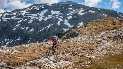
The route becomes increasingly spectacular. In the upper section, the scenery is magnificent: high alpine peaks, many of them over 3000 meters, tower snow-covered and glaciated above the valley. The highest point of the tour is reached at 2375 meters above sea level at the Zopatnitzenalm at the Tauernkreuz. A rustic bench here invites you to take a well-earned rest with a panoramic view.
From now on, it's all downhill. The descent begins moderately, technically rather easy, partly exposed and ranges between difficulty levels S1 and S2. You soon reach the Bergerseehütte - another scenic highlight of the tour. The picturesquely embedded Bergersee lake lies impressively below the southern 3000 m summit chain.
After the hut, the trail becomes more challenging. Tight hairpin bends and blocked passages now demand full concentration. The level of difficulty is between S2 and S3. The trail winds its way over the gorge of the stream down into the Virgental valley, varied and airy in places. This descent is one of the most impressive trail experiences in the entire Alpine region. Once you reach the bottom, you can enjoy a relaxed ride on a gravel path back to the starting point on the Isel.
Note: The climb is easy to ride in places with a light e-mountain bike. Only a few passages require pushing.
Note: The route is located on Austrian territory and leads over routes that are not approved for mountain bikers. Riding this route on a mountain bike is the responsibility of each individual, in full awareness of the legal situation.
Map & GPX-Track
The map is only available to Ride subscribers.
The Ride-Subscription is available at ride-mtb.com/abo
.
Details of the tour
16 km
1030 m
1030 m
1303 above sea level
2337 above sea level
Prägraten
Prägraten
3498
limited
More tours nearby


User comments (0)

About the author: Martin Depauli
Note: This content has been automatically translated from German. Please report any incorrect translations.