

Punta de la Mulattiera West

Description
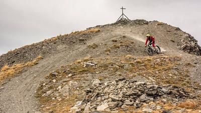
The route starts in Bardonecchia and then descends on side roads and cycle paths to the village of Beaulard. Now you take the old military road through the small village of Puys and then steadily uphill to Punta Colomion at over 2000 meters above sea level. When you reach the ridge for the first time, you can see the lifts to the west and pure nature to the east. Continue along a historic path to the Punta de la Mulattiera (2467 meters above sea level). The entire ridge area is fortified with Vallo Alpino military installations. Some of these are in quite good condition, others were destroyed during the Second World War. What remains, however, is a super tight trail network that is waiting to be explored.
The descent is relatively flowy on difficulty levels S1 to S2 up to the Col des Acles ridge. From here, you then cross the ridge once again in the direction of the Tour Jaune de Barabbas, pushing and carrying yourself up around 100 meters in altitude. Now comes a real trail highlight of the tour. The entire ridge towards Le Mauvais Pas is rushed down on difficulty S2 and later S3. For the photographers among the bikers, this is a real feast. Catalog pictures can be taken here, especially in flat sunshine and at sunset. In the meantime, you reach French soil, cross the pass road and finally immerse yourself in a rather interesting trail firework display before you can roll back down the Rio di Valle Stretta on side roads and the cycle path. Conclusion: A fantastic tour in the middle of the Western Alps on historic trails.
Map & GPX-Track
The map is only available to Ride subscribers.
The Ride-Subscription is available at ride-mtb.com/abo
.
Details of the tour
37 km
1495 m
1495 m
1149 above sea level
2428 above sea level
1 day
Bardonecchia
Bardonecchia
2234
well suited
More information
More tours nearby



User comments (0)

About the author: Martin Depauli
Note: This content has been automatically translated from German. Please report any incorrect translations.