

Punta Sommeiller

Description
The route starts in the summer and winter sports resort of Bardonecchia. From there, the asphalt road winds its way steadily uphill through coniferous forests to Rochemolles. Here you change to the old serpentine road to Punta Sommeiller, which was once used as an access road for skiing. Numerous hairpin bends take you to the Lago di Rochemolles, where the landscape becomes increasingly spectacular and the first buildings of the Vallo Alpino are visible in the rocky slopes. Continue at the same pace to the Rifugio Scarfiotti. Above this, at around 2650 meters above sea level, the route branches off to the right and leads towards Punta Sommeiller, either pushing or carrying.
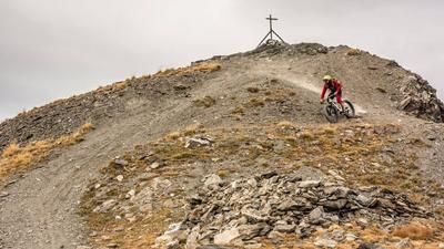
At 3332 meters above sea level, the highest point of the tour is reached - and also the border between Italy and France. After an ascent of over 2000 meters, you are in a real high-altitude rush. The view is magnificent and, in good weather, offers mountain cinema at its finest.
The descent starts rough and challenging at difficulty level S2, in places S3, and leads steadily downhill towards Passo Galambra. Below the Punta Galambra, you reach the Val Fredda, where you cycle downhill on classic gravel with an alpine flair. A very long, varied and rewarding descent begins here, which should not be underestimated due to the surface. At Grangia Valfredda, you reach a gravel road, take two trail cut-offs and then follow the former irrigation ditch above Rochemolles. This parallel path, the Gran Bea Trail, leads directly to the heights of Bardonecchia. At the end, the route leads through the bike park on difficulty level S2 back to the valley station and the last few meters on asphalt rolling out comfortably to Bardonecchia.
Note: If you want to shorten the tour, start in Rochemolles and use the trail cutter back to the village in the Grange La Croix area.
Map & GPX-Track
The map is only available to Ride subscribers.
The Ride-Subscription is available at ride-mtb.com/abo
.
Details of the tour
42 km
1975 m
1975 m
Bardonecchia
Bardonecchia
3556
not suitable
More information
More tours nearby



User comments (0)

About the author: Martin Depauli
Note: This content has been automatically translated from German. Please report any incorrect translations.