

Colle della Rho – Col du Fréjus

Description
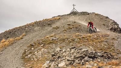
The tour begins in Bardonecchia. From there, the military road leads first on asphalt, then on gravel or coarse cobblestones toward Grange della Rho and on through the Valle della Rho and the famous Tunnel de la Rho to the casemates. The climb here is very challenging and exhausting in places, but at the same time absolutely breathtaking. From there on to Colle della Rho, you’ll only pedal in short stretches—mostly pushing your bike—along cart tracks and singletrack through several military installations of the Vallo Alpino. At Colle della Rho, you stand right between France and Italy; an information sign provides details about the area. After that, the descent begins in the heart of the Cottian Alps. On gravel, you glide easily and freely through the valley down to an elevation of around 2,300 meters above sea level. On the French side lie countless structures of the Maginot Line, impressively built into the landscape.
From this point, the route continues on foot—pushing or carrying your bike—toward Abri sous roche, up to a small mountain pass that is also heavily fortified. After climbing just under 300 meters in elevation, the next descent sequence begins. It winds steadily downhill in switchbacks rated S2 to S3 on loose gravel, offering a high-alpine atmosphere. Passing the Ouvrage de Pas du Roc, you’ll rejoin a service road for the ski area and follow it for a few more meters, past numerous military installations and bunkers, back to the Col du Fréjus. There, the final climb awaits. The subsequent descent, similar to the previous section, ranges from S2 to S3 and leads back toward Bardonecchia, the starting point of the tour. The downhill also features some very smooth sections. At around 1,750 meters above sea level, you’ll rejoin the gravel road, which leads almost all the way back to the starting point and ends with a short trail section. Overall, it’s a very interesting and historic border tour that’s physically demanding but offers countless memorable experiences.
Map & GPX-Track
The map is only available to Ride subscribers.
The Ride-Subscription is available at ride-mtb.com/abo
.
Details of the tour
24 km
1790 m
1790 m
1357 above sea level
2572 above sea level
1 day
Bardonecchia
Bardonecchia
3769
limited
More information
More tours nearby



User comments (0)

About the author: Martin Depauli
Note: This content has been automatically translated from German. Please report any incorrect translations.