

Pendla-Trail

Description
From Schiers, follow the old main road up the valley until just before Pragg-Jenaz station. Turn right here and climb along the asphalt road, bend by bend, into the Walser village of Furna, where time seems to stand pleasantly still. From the village center, we continue up the asphalt mountain road towards Usserberg. Before the path continues at a left-hand hairpin bend to the Grüsch-Danusa ski lifts, we turn onto a forest path in the direction of Teufried. The highest point is reached with a great view of the Schesaplana opposite and the Rätikon.
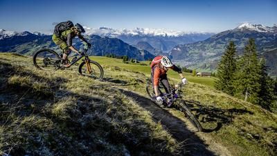
A technically challenging single trail (S3) leads downhill from here to Alp Pendla. After an intermediate section on a gravel road, you head onto the Pendla trail. The upper part is a super singletrail (S2), which becomes a little wider in the lower section. The trail ends at the Grüsch campsite. Along the Landquart river, you reach the starting point in Schiers on gravel roads and intermediate sections on trails.
Map & GPX-Track
The map is only available to Ride subscribers.
The Ride-Subscription is available at ride-mtb.com/abo
.
Details of the tour
23 km
1045 m
1045 m
1 day
Schiers
Schiers
1476
well suited
More information
More tours nearby







User comments (1)

About the author: Thomas Giger
Note: This content has been automatically translated from German. Please report any incorrect translations.
I first looked at the tour on the singletrail map. The descent to Grüsch is marked with black dots throughout, which turned out to be exaggerated. At most the upper 200TM deserve this, the rest should be marked red.
The fact that the forest path is supposed to be two meters wide is also exaggerated, it is in fact a very easy descent, but can be ridden at high speed. In some places, however, there is a risk of falling if you lose control.
All in all, a nice half-day tour with a steep ascent and at the end along the Landquart was also quite relaxing.