

San Nicolao Endless-Trail

Description
This extraordinary tour connects Levanto with Sestri Levante - the return journey is easy by train. Alternatively, the route can also be completed as a circular tour starting in Sestri Levante: Monte San Nicolao is reached via Bargonasco on the SP60 and later via the SS1 - both mountain roads with little traffic.
However, the variant with Levanto as the starting point is more appealing: a wonderful asphalt ascent takes you to Colle di Guaitarola, accompanied by wonderful views of the Ligurian cliffs at Bonassola. The first part of the ascent is completed at the Colle, followed by a lonely transfer section into the hinterland. Soon you reach the foot of Monte San Nicolao, whose numerous transmitting antennas mark the summit. A small, steep road leads up on asphalt - the view from the top is spectacular and extends from Portofino to the Cinque Terre.
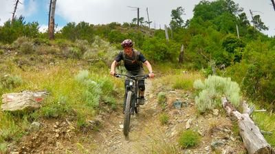
The summit marks the starting point for a seemingly endless singletrail descent to Moneglia. The trail runs playfully along the ridge, sometimes fast, sometimes more technical - again and again, fantastic views of the Deiva Marina basin open up. You then reach the main road and scramble up a few meters in altitude on the opposite side before immediately turning into the next section of trail. This first follows the ridge, then the eastern mountain flank. Short counter-climbs occasionally interrupt the flow before the trail finally rides to Lemeglio above Moneglia. The restaurants on the coast or in the pretty old town are perfect for an enjoyable stop.
If you want to finish here, simply take the train back to Levanto. If you want more, climb up a small, asphalted mountain road. As soon as you reach the main road, you push your bike up a path on the left - a feat of strength over around 200 meters in altitude that leads to the varied final descent to Sestri Levante. Super flowy at first, a little more technical after the chapel, then smoothly parallel above the road again - and at the end with a few steep sections that will put a big grin on the faces of experienced riders. You reach the bottom of the valley under the highway bridge, continue along small roads and cycle paths and finally end up on the picture-postcard beach of Sestri Levante.
Conclusion: an exceptional tour with lots of trails and numerous scenic attractions. Here you get a great insight into the hinterland of Sestri Levante.
Map & GPX-Track
The map is only available to Ride subscribers.
The Ride-Subscription is available at ride-mtb.com/abo
.
Details of the tour
43 km
1495 m
1495 m
4 above sea level
837 above sea level
1 day
Levanto
Sestri Levante
3416
well suited
More information
Pictures from the tour


More tours nearby




User comments (2)

About the author: Thomas Giger
Note: This content has been automatically translated from German. Please report any incorrect translations.
The paved climb and the transfer section aren’t so bad when you consider the view—it’s wonderful. The description is spot on: “Endless Trail,” and it has a bit of everything—flow, technical sections, loose rocks, solid rock, and boulder fields—but depending on your skill level, (almost) everything is rideable. An e-mountain bike is recommended because of the uphill sections, so you can stay in that super-flow. (The trail has apparently been maintained since June.)
We only went as far as Moneglia, since we were riding e-mountain bikes and the second section sounded like it would involve a lot of pushing and carrying. That’s why we skipped that part. Unfortunately, you’re not allowed to ride the bikes back along the coast to Levanto. The bike path doesn’t start until Framura. That means if you don’t want to take the train: another roughly 600 meters of elevation gain and 30 kilometers back on a road.
The first 16 kilometers and 660 meters of elevation gain are covered on a paved road, and it feels more like a road bike ride than a mountain bike tour. If you’re pedaling on your own, you won’t enjoy this part, and I recommend a more direct ascent from Framura or Deiva Marina. You’ll be rewarded for the climb with the fantastic San Nicolao Trail, which is in excellent condition. The trail that follows after Monte Salto del Cavallo is less fun to ride. The trail is no longer maintained and has some technical uphill sections. Next time, I’d try a different route here. The final trail to Moneglia is easy to ride. To get to Monte Moneglia, I had to carry my bike a few times. I wouldn’t bother with this climb on an e-bike. The descent to the chapel is smooth and flowing. After the chapel, the path turns into a bumpy track until you turn right onto the trail. Currently, there is a tree lying on this trail that is difficult to get around. The final trail below the highway is heavily overgrown. Conclusion: I would choose a different descent route starting from Monte Moneglia.