

Colle di Neraissa

Description
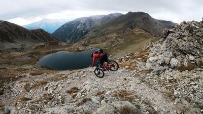
The tour begins in Vinadio, probably the most famous municipality in the Valle Stura. This district was heavily fortified in the 1840s and, together with the Fenestrelle fortress and the Forte di Exilles, forms the most striking examples of Piedmontese defensive structures. From Vinadio, the route rides first on asphalt and later on gravel to Neraissa Inferiore. Here you have the opportunity to top up your water reserves before finally tackling the military road with its breathtaking panorama up to the Colle di Neraissa pass. The ascent is entirely on gravel and can seem a little monotonous due to the straight route. At Colle di Neraissa, you have the option of integrating Monte Autes into the tour. It is worth mentioning that both the ascent and descent are very easy and flowy, but an outstanding panorama awaits you at the summit. At the pass itself, there are remains of the Forte Colle di Neraissa and first glimpses of the upcoming trail descent, which is relatively varied and has difficulty levels from S1 to S2.
The extreme rock formations in the Valle Stura can also have a detrimental effect on the trails, however. Some of these can be washed out or eroded after weather events or heavy rain, although such sections are limited. The majority of the trail rides through Mediterranean vegetation, combined with hairpin bends and flow segments, all the way down to Sambuco. In Sambuco, you then come across a gravel road and follow the official cycle route, which rides away from the busy main road back to Vinadio.
Map & GPX-Track
The map is only available to Ride subscribers.
The Ride-Subscription is available at ride-mtb.com/abo
.
Details of the tour
28 km
1120 m
1120 m
860 above sea level
2006 above sea level
1 day
Vinadio
Vinadio
3207
well suited
More information
More tours nearby




User comments (2)

About the author: Martin Depauli
Note: This content has been automatically translated from German. Please report any incorrect translations.
June 24, 2026: Current condition is very poor; in at least four places, water has washed away the trail in the upper section, and on the scree slope beyond that, the crossing with the logs is similarly buried. It is truly dangerous. The trail was repaired by the municipality in 2026, but is now in poor condition due to two rainstorms over the past four days. It is unclear when repairs will be made again.
Beautiful tour. Descent in good condition. A little exposed in places, but not too wild...