

Testa dell'Autaret - Passo di Barbacane

Description
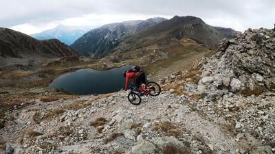
The starting point of the tour is the hamlet above Bagni di Vinadio called Callieri. From here, you pedal leisurely on asphalt to San Bernolfo before taking the military road. This rides steadily uphill via the Rifugio De Alexandris and the Lago di San Bernolfo. From the lake onwards, the uphill becomes very demanding and requires strength. These exertions are rewarded with a panorama in a class of its own. At around 2450 meters above sea level, you will find the first parts of a huge defensive structure from the 1930s. Directly at the national border at the Lacs de Colle Longue, the route continues from the military road onto an alpine path to the Pas de Colle Longue. From here, the bike is then only transported by pushing or carrying it up to the Testa dell'Autaret (2754 meters above sea level). There are always relics and historical buildings on the ascent. This also applies to the summit, although some of these have been blown up and destroyed. As is usual with military installations, you have the best view at the highest point, as is the case at this summit. A breathtaking view that shows the Maritime Alps at their best.
The descent is also at its best. Initially relatively ingrown and challenging, the route continues on difficulty levels S2 to S3 down to the Pas de Colle Longue. In the upper section, you should be careful when crossing, as it is exposed. From the Pas de Colle Longue, you finally cross the entire mountain under the Cima di Collalunga. However, the path is destroyed in two places here and the bike has to be pushed. After that, a first-class singletrail begins. On difficulty levels S1 to S2, you virtually surf through France before taking the high route under the Pointe de Costa Plana and the carrying section towards the Passo di Barbacane. From here, the bike has to be carried from 2200 meters above sea level to 2587 meters above sea level. The path is difficult to find and requires a certain amount of alpine surefootedness. The last section in particular challenges the biker once again. Once you reach the Passo di Barbacane, you again have a view of the Valle Stura and the trail descent. Difficulty S5 is the order of the day at the barracks, which most bikers complete by pushing. From the barracks, a fantastic singletrail of difficulty S2 begins and rides steadily downhill to San Bernolfo. In the intermediate section, you can then vary between S2 and S3, depending on the shortcut option and choice of route. From San Bernolfo, you then cross a few more trail cut-offs before returning to the starting point.
Map & GPX-Track
The map is only available to Ride subscribers.
The Ride-Subscription is available at ride-mtb.com/abo
.
Details of the tour
27 km
1620 m
1620 m
1453 above sea level
2695 above sea level
1 day
San Bernolfo
San Bernolfo
2715
well suited
More information
More tours nearby




User comments (1)

About the author: Martin Depauli
Note: This content has been automatically translated from German. Please report any incorrect translations.
We did this on 10.07.2025 from Sambuco without the detour to Testa dell Autaret with e-bikes. Can confirm everything as described above. Small restriction: the e-bike classification "well suited" is very sporty, you have to carry at least 250 hm over large blocks steeply to the pass. Very beautiful scenery, sparkling quartz crystals in the rock on the ascent before the pass, hardly any hikers after Colle Longue, no bikes. Great experience, would love to do the ascent again, but then ride the Cima Tommy variant.