

Passo Scolettas

Description
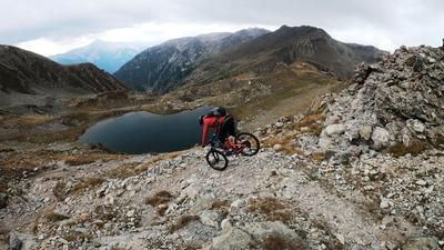
The starting point is the village of Pietraporzio in Valle Stura. From here, you pedal steadily uphill along the former military road of the Vallo Alpino past the Pian della Regina with a fantastic backdrop to the Gias del Piz. At Gias del Piz, the route then climbs up to Passo Scolettas (2225 meters above sea level) on a relatively easy singletrail. After passing through the tunnel at the end of the uphill section, you have to push your bike for a short time before finally reaching the highest point of the tour. On the pass, you are surrounded by a breathtaking mountain panorama that is second to none.
The descent is also second to none. A perfect military installation of the Vallo Alpino is now taken under the studs. At difficulty level S2, the route descends above the tree line in classic hairpin bend style. At an altitude of around 2000 meters above sea level, the difficulty increases slightly, but the level remains at S2. Once you reach the bottom of the valley at the Rifugio Alfredo Talarico, the route continues up the valley floor on gravel in the direction of Valle Stura, before taking the uphill again at the fork in the road in the direction of Murenz and a natural trail with difficulty levels S2 to S3 to Pontebernardo. Once in Pontebernardo, the route then follows the Stura di Demonte back to the starting point.
Map & GPX-Track
The map is only available to Ride subscribers.
The Ride-Subscription is available at ride-mtb.com/abo
.
Details of the tour
17 km
990 m
990 m
1254 above sea level
2213 above sea level
1 day
Pietraporzio
Pietraporzio
2655
well suited
More information
More tours nearby




User comments (2)

About the author: Martin Depauli
Note: This content has been automatically translated from German. Please report any incorrect translations.
Very nice tour! I agree with the previous writer on some points. Only those who are not male, young and fit will push up a lot here. The last downhill bends before Refugio Alfredo are steep and rather S3. After that, there is still a nice slope for fans of rear wheel offsets. The tightest bends follow after the intermediate climb! Please do not take shortcuts (unfortunately there are already tracks) and damage the trail, but ride the bends with rear wheel offset!
Beautiful tour.
The first 200m are very steep on asphalt, then it continues steeply on rough gravel. Apart from a few places with deep gravel (1-2 min), everything is rideable up to the pass, even without a motor.
On the pass there is a well, flat bivouac spots and a shelter without any other amenities.
The descent is S1-S2 at the top, further down there are many gravel hairpin bends, but these can be ridden without shifting the rear wheel. I would say S2-S3...
The Colle jam can be tacked on afterwards.