

Lago Lausfer Superiore – Buco della Marmotta

Description
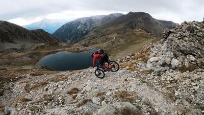
The starting point is the exit road just below San Bernolfo. From here, you pedal relaxed on asphalt to San Bernolfo and then quite steeply on gravel to Lago Lausfer Superiore. From an altitude of around 2000 to 2100 meters above sea level, pedalling comes to an end. Although the military road is still in very good condition, it is no longer suitable for a sensible climb. The route then continues up the former Vallo Alpino supply route, zigzagging steadily uphill. At an altitude of 2400 meters above sea level, you then cross the terrain that continues to Lago Lausfer Inferiore and then to Lago Lausfer Superiore. At the last lake there is also a Vallo Alino barracks, somewhat bizarre-looking next to the shore. If you want, you can shoulder the bike even further and then carry it towards Buco dell Marmotta, the start of the via ferrata. Once you reach the highest point of the tour, you have a good view of the basin, the mountain lakes and the descent. On difficulty levels S2 to S3, the route descends to the first and then the second lake. From here, the trail becomes somewhat easier and is classified as difficulty S1 to S2. The ascent variant with the hairpin bends can be shortened here, whereby these shortcuts have difficulty level S3. In the lower section, it becomes a little easier again before you finally roll out onto gravel to San Bernolfo and then take the trail cut-offs to the starting point of the tour.
Map & GPX-Track
The map is only available to Ride subscribers.
The Ride-Subscription is available at ride-mtb.com/abo
.
Details of the tour
18 km
1200 m
1200 m
1538 above sea level
2753 above sea level
1 day
San Bernolfo
San Bernolfo
2708
not suitable
More information
More tours nearby




User comments (0)

About the author: Martin Depauli
Note: This content has been automatically translated from German. Please report any incorrect translations.