

Beccho Rosso

Description
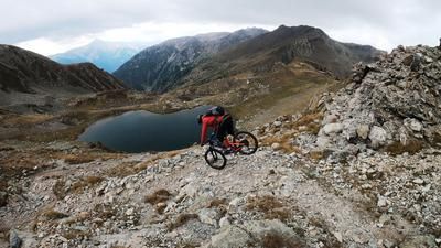
The route starts in the small, idyllic village of Pontebernardo. From here, the route initially follows the main road, later bypassing the gallery and then returning to the main road to Villaggio Primavera. From Villaggio Primavera, the route winds its way through Val Forneris until the pedalable part of the tour ends at just under 1700 meters above sea level and the bike is pushed and carried up an old mule track to Beccho Rosso. The Beccho Rosso is an advanced mountain ridge that was fortified with countless military installations from the Second World War.
The following trail descent is on the top. Between difficulty levels S1 and S2, the old mule track descends steadily. Above Murenz, you then join a gravel road, have to roll down it and from Murenz you can also complete a trail with difficulty levels S2 to S3 on some challenging hairpin bends back to Pontebernardo.
Map & GPX-Track
The map is only available to Ride subscribers.
The Ride-Subscription is available at ride-mtb.com/abo
.
Details of the tour
16 km
900 m
900 m
1 day
Pontebernardo
Pontebernardo
2995
not suitable
More information
More tours nearby




User comments (1)

About the author: Martin Depauli
Note: This content has been automatically translated from German. Please report any incorrect translations.
I started at 1900m (coming from Colle Stau). From there 350m pushing up. About 10min of it also a bit tedious. So rather nothing for e-bikes from this side.
The descent is then on a classic military trail singletrail with a 10-14% gradient and S1.
From this side, the trail would probably be rideable uphill all the way, especially for e-bikes...