

Testa dell'Autaret - Colletto San Bernolfo

Description
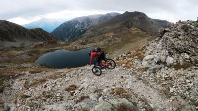
The route starts in the small village of San Bernolfo in Valle Stura. From here you are not spared and the route climbs up a former military road from the Second World War, past the Lago di San Bernolfo to the former position at Lacs de Colle Longue. An indescribable panorama and a bizarre arrangement of building complexes from the last century together offer one of the most interesting tours in the entire region. From the Lacs de Colle Longue, you push your bike past the Pas de Colle Longue up to 2745 meters above sea level on the Testa dell'Autaret. Due to the Vallo Alpino constructions, this ridge was an important point of defense, today it offers a 360-degree panorama that must be seen.
The descent is also a must. At the summit, you descend the ascent, which was tackled by pushing or carrying. At difficulty levels S2 to S3, there are some fairly exposed sections to master. From the main ridge, you surf down to just above the Lac de Colle Longue. Continue in this manner to Colle di Seccia. The trail spectacle continues from Colle di Seccia. From the Lago di Seccia, the final uphill to the Colletto San Bernolfo is on difficulty S2 and occasionally S3. Here the bike has to be pushed or carried once again up to an altitude of 2555 meters above sea level before the brilliant finale downhill. In the meantime, a work of art in road construction has mutated into a fantastic trail. On difficulty level S2, the route leads to Lago di San Bernolfo on an infinite number of hairpin bends and in a dreamlike landscape. From Lago di San Bernolfo, you have the option of taking the ascent variant on rough gravel or the enduro variant on a trail that varies greatly. This alternates between difficulty S2 and in places S4 and even S5 before you get back to San Bernolfo.
Map & GPX-Track
The map is only available to Ride subscribers.
The Ride-Subscription is available at ride-mtb.com/abo
.
Details of the tour
21 km
1150 m
1150 m
1673 above sea level
2694 above sea level
1 day
San Bernolfo
San Bernolfo
2624
limited
More information
More tours nearby




User comments (0)

About the author: Martin Depauli
Note: This content has been automatically translated from German. Please report any incorrect translations.