

Cime des Blanches – Testa del Ferro

Description
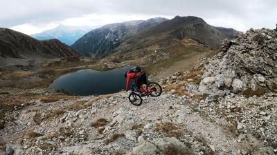
The tour begins in picturesque Pontebernardo in Valle Stura and rides steadily uphill on gravel along the military road towards Prati del Vallone. At the Rifugio Alfredo Talarico, you change to a mulattiera path, which is part of the defensive fortifications of the Vallo Alpino, which characterizes the Valle Stura along the French border. The ascent to the Cime des Blanches/Testa del Ferro is mostly pedalable, which is particularly advantageous for e-bikers. The trail offers an outstanding experience with countless hairpin bends and breathtaking panoramic views of the Testa di Garbe and on to the summit.
Shortly below the Testa di Garbe, the trail is affected by erosion, which means that pushing and carrying sections must be expected at an altitude of around 50 meters. You then cross the ridge and tackle the summit. At the highest point of the tour, right on the border with France, you can enjoy spectacular views, including of the Monviso.
The descent begins at the border area and briefly takes you to the French side of the Mercantour National Park, where biking is prohibited. However, this section is only short-lived and from the Col du Fer saddle at 2584 meters above sea level, you are back on Italian territory and can enjoy the trail to the full. The descent, which varies between difficulty levels S2 and S3, winds its way steadily down past the Pian Belvedere. This never-ending downhill offers not only technical riding pleasure but also a breathtaking panorama. Finally, you reach Villaggio Primavera back in Valle Stura and take small trail cut-offs back to the starting point.
Map & GPX-Track
The map is only available to Ride subscribers.
The Ride-Subscription is available at ride-mtb.com/abo
.
Details of the tour
26 km
1430 m
1430 m
1305 above sea level
2710 above sea level
Pontebernardo
Pontebernardo
3231
limited
More information
More tours nearby




User comments (1)

About the author: Martin Depauli
Note: This content has been automatically translated from German. Please report any incorrect translations.
A wonderful tour past some lost places in an unreal landscape. After the crossing along the ridge, you start onto a fantastic trail that definitely shows its teeth and requires certain skills. To avoid the descent via the forest road in the lower section, you can join the tour up the Becco Rosso after crossing the Rio Forneris. Then, with a few additional meters of elevation gain, there is trail fun right to the very end.