

Passo di Bravaria

Description
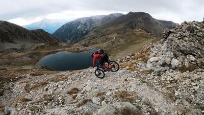
The tour begins in the Stura Valley. In the small village of Pratolungo, you first follow the SP255 on paved road steadily uphill, accompanied by impressive scenery, until you turn off toward Sant'Anna di Vinadio; the route is relatively easy to navigate up to this point. This pilgrimage site is the highest in Europe, situated at 2,035 meters above sea level. From there, the route continues in sections—sometimes pushing the bike, sometimes pedaling—along the B17 long-distance hiking trail toward Passo di Bravaria at 2,311 meters above sea level. The pass has a high-alpine character, is marked by rugged rock formations, and then leads toward Bagni di Vinadio.
On the Sentiero B16 trail, rated S2 and S3 in difficulty, the route descends relatively steadily through the Vallone d’Insciauda valley. You ride down through mostly forested terrain before reaching the village of Bagni di Vinadio. The village is nestled among steep rock faces; from this point on, only the paved road leads back to the Valle Stura, and then the bike path takes you back to the starting point.
Map & GPX-Track
The map is only available to Ride subscribers.
The Ride-Subscription is available at ride-mtb.com/abo
.
Details of the tour
31 km
1385 m
1385 m
912 above sea level
2274 above sea level
1 day
Pratolungo
Pratolungo
3780
limited
More information
More tours nearby




User comments (0)

About the author: Martin Depauli
Note: This content has been automatically translated from German. Please report any incorrect translations.