

Monte Scaletta

Description
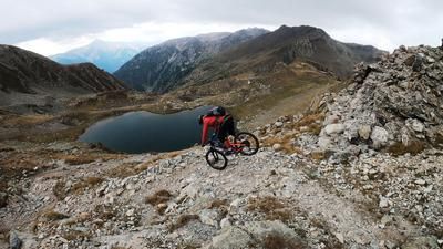
This extraordinary tour starts in the small village of Argentera in the Valle Stura between Cuneo and Barcelonette. From here, the route climbs up the pass road on asphalt to the Rifugio della Pace and then on to the Colle della Maddalena at 2000 meters above sea level. Up to here you have 100% asphalt under the studs and now the uphill changes to a narrow path, which is initially still rideable. However, after around 250 meters of altitude, the bike has to be pushed and carried for a short time before there are opportunities to pedal again at Lac de l'Orrenaye. The route continues up to the Colle di Roburen (2502 meters above sea level). In the midst of an impressive mountain panorama, you reach the section of the Italian/French border again. Surrounded by huge mountain formations and beautiful mountain lakes that are more reminiscent of a Walt Disney movie than a bike tour in the Alps - that Western Alps feeling! A traverse follows from the pass and then the ascent to the Colle della Scaletta continues. Already at the Colle della Scaletta (2614 meters above sea level) you can see fragments from the Vallo Alpino time again and again. Now comes the spectacular section of the tour. The ascent to Monte Scaletta rides through a Vallo Alpino bunker in the middle of the mountain. It is only with great difficulty that you get your bike through the gears and continue to the summit. It should be noted, however, that a head for heights and alpine experience are a must. At the summit (2840 meters above sea level), the world is literally at your feet. An incredible panorama of the surrounding mountains, which also makes you understand the military significance of the buildings that were erected at the time.
The descent runs along the entire ridge to the south-east. Some sections can be ridden here, some have to be pushed as the risk of falling is relatively high. The difficulty of the trail gradually decreases and you come to an old pioneer trail with a difficulty of S2 to S3 that rides down to Lago Mediano di Roburent. From here it feels like an eternity down to La Tinetta and on to the starting point. The level of difficulty here is S2, although there are short S3 sections that challenge the biker once again. Fazuit: All in all, the military buildings and lost places make this one of the craziest bike tours in the entire Alpine region and, with good visibility and stable weather conditions, an absolute highlight in the Valle Stura region.Map & GPX-Track
The map is only available to Ride subscribers.
The Ride-Subscription is available at ride-mtb.com/abo
.
Details of the tour
23 km
1140 m
1140 m
1704 above sea level
2777 above sea level
1 day
Argentera
Argentera
2172
not suitable
More information
More tours nearby




User comments (3)

About the author: Martin Depauli
Note: This content has been automatically translated from German. Please report any incorrect translations.
Today I crossed Monte Scaletta on foot from Viviere. Taking your bike up to the summit is a bad idea. Leave it down by the lake and do the crossing on foot. It’s still a T5 hike. Also, I don’t understand how anyone could describe the route to Lac de Orronaye—which also goes through Passo Scaletta—as unsuitable for e-bikes. With a little bit of grit, it’s the ideal e-bike tour.
Because of the previous comment, I was warned and tried to go up from Lago di Roburent on the downhill route. Just as well. From an altitude of 2500 m, it no longer made sense. That is absolutely no biking terrain up there. If you're not a pro, it's not rideable. And crossing it by bike is life-threatening. I don't know what the author was thinking, but in my opinion this tour has no place on a tour portal, especially with such a trivializing description.
Life-threatening! A dream on foot, a nightmare by bike. Leave your bike at Colle di Roburent or Lago di Roburent and do the Monti Scaletta, with mountain ridge, on foot!