

Cima Tommy

Description
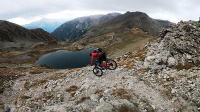
The tour starts in Vallestura just below the village of San Bernolfo. From here, there are four hairpin bends on the asphalt road to the fork to Lago di San Bernolfo. From here, a huge network of military installations from the Second World War opens up. These can be used perfectly as a climbing aid and are also used in this case via the Lago di San Bernolfo up to the old barracks (Caserma di Collalunga) at over 2400 meters above sea level. The ascent is easy to ride in the lower third and becomes increasingly difficult as the altitude increases, with e-bikers clearly having the edge here. From the saddle, the dividing point between Italy and France, the route heads north to Cima Tommy (2614 meters above sea level). The Cima Tommy itself is an inconspicuous but very scenic summit in the middle of the Maritime Alps and makes bikers' hearts beat faster - even if the descent is not easy.
The top 50 meters of the descent have to be completed by pushing. Not because of the difficulty of the trail, but because the remnants of the war make it unrideable. It feels like you would have 1000 punctures in your tires if you rode the upper part. From an altitude of 2550 meters above sea level, things get going. Down to Colle di Seccia, a little bumpy at the start and then endless flow to the bottom of the basin towards Guglia di San Bernolfo. The 300 meters in altitude give you an idea of what to expect - but you have to push briefly for 150 meters on a counter-climb. From the saddle, an endless trail with a difficulty of S1 to S3 leads down to the Lago di San Bernolfo. Here, the route briefly descends the ascent road again before a few trail cut-offs cross the path again and again. This is how you reach the starting point. Conclusion: All in all, a breathtaking, historic tour with a lot of Western Alps flair. Less frequented and an absolute highlight even in the high season, as the lakes provide the perfect opportunity to cool off.
Map & GPX-Track
The map is only available to Ride subscribers.
The Ride-Subscription is available at ride-mtb.com/abo
.
Details of the tour
20 km
1230 m
1230 m
1472 above sea level
2572 above sea level
1 day
Bagni di Vinadio
Bagni di Vinadio
2052
well suited
More information
More tours nearby




User comments (0)

About the author: Martin Depauli
Note: This content has been automatically translated from German. Please report any incorrect translations.