

Colle di Stau

Description
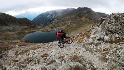
The starting point is the small village of Pontebernardo in Valle Stura above Pietraporzio. From here, the route climbs steadily uphill on asphalt and gravel to the Rifugio Alfredo Talarico. From here you can still pedal a few meters on a biobike before finally climbing up a Vallo Alpino path via Gias de Stau to Colle Stau (2500 meters above sea level). E-mountain bikers can rejoice, as the uphill is rideable almost all the way. Biobikers have to push their bikes for longer in some places. At Colle di Stau, at just under 2500 meters above sea level, you find yourself embedded in a fabulous landscape. Monte Peiron to the south and the views of the Gardetta plateau and Monte Scaletta to the north leave nothing to be desired.
The descent also leaves nothing to be desired. At difficulty level S2, the route descends steadily. A never-ending trail! Varied, scenic and a dream, especially in autumn with its colorful vegetation. In this style, the route finally heads out of the valley to Villaggio Primavera. From Villaggio Primavera, there is another gear change and an uphill before the final trail descent at Murenz. On difficulty levels S2 to S3, the last few Elevation losses lead down to the starting point.
Map & GPX-Track
The map is only available to Ride subscribers.
The Ride-Subscription is available at ride-mtb.com/abo
.
Details of the tour
21 km
1280 m
1280 m
1291 above sea level
2470 above sea level
1 day
Pontebernardo
Pontebernardo
2651
well suited
More information
More tours nearby




User comments (3)

About the author: Martin Depauli
Note: This content has been automatically translated from German. Please report any incorrect translations.
The difficulty of the tour should be rated higher. Very steep and slippery at the top, then easy to ride in the middle section (S2-S3). But then steep again up to the bridge over the river, exposed and with lots of erosion gullies. The last descent to Murrenz is also steep and exposed. Overall, I pushed a lot. The Col di Puriac and Cimes des Blanches tours in the surrounding area are much more rewarding.
The start of the descent is nice. Unfortunately, at the end of August, the trail in the steep section was so washed out that it was practically unrideable. The narrow erosion gullies were too deep.
I started at the Rif. Talarico (1700m). The uphill from there to Gias di Stau is steep but rideable. The following singletrail has a gradient of between 10-14% and can be ridden almost all the way with the right amount of power, even without a motor. Only the tight bends sometimes force you to get off the bike.
The descent is in the S2-S3 range. Unfortunately, some branches protrude into the trail. If you like, please bring a folding saw and remove the worst of it. Thank you.
Afterwards, "Becchi rossi" can be tacked on with a 350 m pushing passage.