

Passo di Rocca Brancia

Description
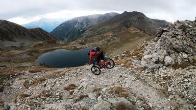
The route starts in the small village of Pietraporzio in Val Stura near Cuneo. From here, a seemingly endless but breathtaking and panoramic military road climbs steadily uphill to the Colle della Guia and on to the Colle di Salsas Blancias pass (2470 meters above sea level). The ascent is extremely long, but thanks to the good surface and varied landscape, this uphill is also doable for those without an iron will. You then take the legendary Strada ex militare verso gardetta and wind your way through an unreal world of World War II buildings in the Vallo Alpino, with breathtaking viewpoints and lost places along the way. At the Rifugio della Gardetta (2375 meters above sea level) it is worth stopping for a break or to recharge your e-bike battery. Continue up the last few meters uphill, which now become more difficult, on the military road to the Passo di Rocca Brancia (2620 metres above sea level), the highlight of the tour.
At the pass, there is a direct view down into the Valle Stura. You can already see the first signs of the superlative trail. Initially passing huge bunkers of the Vallo Alpino, you surf from top to bottom on a difficulty of S1 to S2 directly down to Pontebernardo. Before that, there is a bypass of the Strada Statale 21 on the old route and a few small and fine trail detours. In the town itself, you then cross the main road again and take the last few meters back to the starting point. The tour is particularly attractive in autumn, as the coloring of the vegetation and the clear air offer an enormous adventure and relaxation factor.
Map & GPX-Track
The map is only available to Ride subscribers.
The Ride-Subscription is available at ride-mtb.com/abo
.
Details of the tour
34 km
1635 m
1635 m
1226 above sea level
2608 above sea level
1 day
Pietraporzio
Pietraporzio
2171
well suited
More information
More tours nearby




User comments (1)

About the author: Martin Depauli
Note: This content has been automatically translated from German. Please report any incorrect translations.
I rode the tour today - sensational! We took a shuttle up to Colle Valcavera for the ascent. The Gardetta road is great, even if it is a gravel road, but the scenery is superb. The ascent to Rocca Brancia through the rocky section is spectacular and the long singletrail descent into Val Stura is a great mix of S2 and S3 with fast passages, serpentine sections, steep sections and flat sections - everything is included. A highly recommended route!