

Spronserjoch

Description
The tour starts north of Merano, near the village of Tirol. To avoid the monotonous drive into the Passeier Valley, it’s recommended to take a shuttle service or public transportation all the way to St. Leonhard in Passeier—that way, you’ll have more energy left for the actual tour.
From St. Leonhard, the route first heads uphill on paved road through Platt to Pfelders. Shortly before the climb to the Eisjöchl, you’ll switch to the forest road—or Karnweg—which leads toward the Falschnaljöchl and on to the Spronserjoch. Up to about 2,100 meters above sea level, the uphill climb is mostly rideable, even though some sections are already quite steep. After that, the route gradually transitions into a trail; sections where you’ll need to push your bike and pedal in stretches are unavoidable all the way to the Falschnaljöchl at about 2,400 meters above sea level.
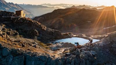
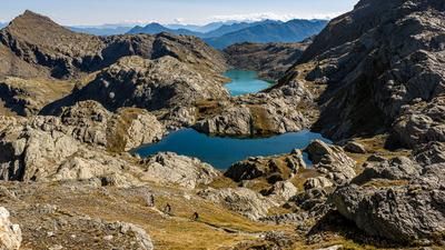
The highest point of the tour is finally reached at the Spronserjoch, which lies at just under 2,600 meters above sea level in the midst of a legendary mountain landscape—surrounded by clear lakes and bizarre rock formations.
The descent toward the south is varied and peppered with key sections. In the upper section, the difficulty is rated S3, with granite slabs and boulder fields requiring full concentration, precise line choice, and active riding. Afterward, the trail transitions into a paved section and leads to the Meraner Hütte, which now exists only as a ruin. Here, the descent becomes easier, and from the Oberkaser mountain hut onward, the difficulty levels off between S1 and S2. For the most part, the ride is smooth, but technically challenging sections pop up every now and then, adding variety.
At the Longfaller Hut, you have two options:
- Either take the relatively easy Waalweg trail, which leads directly into the valley.
- Or you can incorporate a traverse with a short uphill section and then enjoy the Hochübelweg, which rounds out the tour with another trail highlight.
At the end, you’ll reach civilization again and ride back to the starting point near Dorf Tirol.
Conclusion: A very long, physically demanding tour with magnificent panoramic views and a descent that’s second to none. Using a shuttle to the Passeier Valley or even as far as Pfelders is highly recommended to conserve energy for the main highlight—the endless trails.
Map & GPX-Track
The map is only available to Ride subscribers.
The Ride-Subscription is available at ride-mtb.com/abo
.
Details of the tour
39 km
2045 m
2240 m
497 above sea level
2558 above sea level
1 day
St. Leonhard in Passeier
St. Leonhard in Passeier
3510
limited
More information
No bike shops are registered for this region. Registration as a partner takes place here.
More tours nearby








User comments (1)

About the author: Martin Depauli
Note: This content has been automatically translated from German. Please report any incorrect translations.
In September 2026, I combined the Spronserjoch with the Eisjöchl—a really awesome combo, but it pretty much requires an e-mountain bike. The Eisjöchl is easy to tackle on an e-mountain bike anyway, and the Spronserjoch also works perfectly with the pedal-assist feature. What isn’t emphasized enough in the description here is the fascinating lake landscape right at the start of the descent from the Spronserjoch. The terrain is hard to beat in terms of beauty. This backdrop alone makes the tour worth it!