

Wandberg-Runde

Description
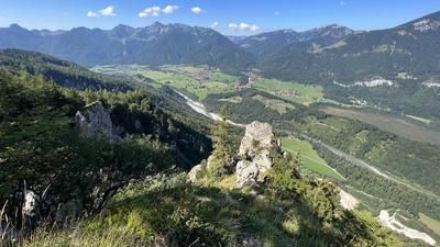
The starting point of the tour is Rettenschöss near Walchsee. You climb up a gravel road, pass Feistenau and later the Rettenbachalm and finally reach the Burgeralm Burgerhütte on the Wandbergalm (1330 meters above sea level). Here you can take a break and enjoy the magnificent panoramic views of the Inntal valley and the Zahmen Kaiser. If you like, you can climb the Wandberg (1454 meters above sea level) in about 15 minutes - from a mountain biking perspective, however, the summit is of no significance.
The descent begins at an alpine hut around 200 meters west of the Burgerhütte, which is reached via a short climb (pushing). Follow the flowing trail in a south-easterly direction until you reach the ascent route again at 1220 meters above sea level. Roll downhill along the road until it makes a 90-degree right-hand bend. Here, follow the signs to the left in the direction of Wildbichl Alm along a beautiful root trail. Once you reach the Wildbichlalm, take an unsignposted path to the right of the road directly behind the terrace, first across a meadow and later in the forest. Follow this beautiful trail until you reach the road again just above the Dagnalm (941 meters above sea level). Continue in the direction of Ritzgraben. In the last left-hand bend, you have the opportunity to take a short trail in the direction of Sachrang and then shortly afterwards a short asphalt ascent to the Ritzgraben hiking parking lot. You now roll back to Rettenschöss on a small road.
Note: The route is located on Austrian territory and leads over routes that are not approved for mountain bikers. Riding this route on a mountain bike is the responsibility of each individual, in full awareness of the legal situation.
Map & GPX-Track
The map is only available to Ride subscribers.
The Ride-Subscription is available at ride-mtb.com/abo
.
Details of the tour
16 km
760 m
760 m
681 above sea level
1385 above sea level
1 day
Rettenschöss
Rettenschöss
2422
well suited
More information
More tours nearby






User comments (0)
Note: This content has been automatically translated from German. Please report any incorrect translations.