

Monte Legnarola West

Description
The route starts in the village of Semonzo del Grappa. From here, you wind your way up the asphalt road towards Monte Grappa to the highest point of the tour, Monte Legnarola (1327 meters above sea level). It should be noted, however, that the last few meters to the summit are on a service road. For all those who prefer a shuttle, this is possible, as a shuttle service can be used up to the junction of the service road without any problems.
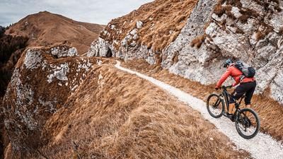
The downhill then begins from Monte Legnarola. Directly along the ridge, the route heads towards Campo Croce on difficulty S2 before reaching the final downhill section at Campo Croce below the Monte Grappa pass road. It should be noted here that the tour is only suitable to a limited extent in the rain, as the trail runs partly on earth and this offers a mixture of olive oil and Nutella in combination with hairpin bends when wet. Most of the time, the downhill is at difficulty level S2, before it gets more difficult at the end and the trail shows some teeth, but ends directly at the starting point of Semonzo del Grappa.
Map & GPX-Track
The map is only available to Ride subscribers.
The Ride-Subscription is available at ride-mtb.com/abo
.
Details of the tour
20 km
1100 m
1100 m
196 above sea level
1300 above sea level
1 day
Bassano del Grappa
Bassano del Grappa
2211
well suited
More information
More tours nearby






User comments (0)

About the author: Martin Depauli
Note: This content has been automatically translated from German. Please report any incorrect translations.