

Nevesjoch

Description
The tour begins in Sand in Taufers and winds its way along the cycle path via the Mühlwaldertal valley to the Neves reservoir (1856 meters above sea level), initially flat and later somewhat steeper uphill. As soon as you enter the Mühlwalder valley, it is clear what a fantastic mountain landscape you are entering, with the mountain scenery becoming more and more like the Western Alps with every meter of altitude you climb. From the Neves reservoir, the route initially follows a forest road and later a cart track to the Chemnitzer Hütte. For e-mountain bikers, this ascent is completely rideable, for organic bikers it's "no mercy for the calves". At the Chemnitzer Hütte, you can enjoy a good meal when the hut is open.
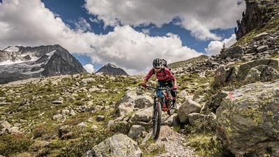
Be careful on the descent, as nothing is given to you here. From the Joch to the Gögealm, the descent is at S3 level and makes enduro fans' hearts beat faster. From the Gögealm, there are a few more trail cut-offs down into the Weißenbachtal valley. However, to avoid wasting unnecessary Elevation loss on the forest road, take an additional uphill in Weißenbach via the Buseggealm to the Schöllbergalm. The question of whether this makes sense becomes superfluous once you have entered the trail section on the 18er hiking trail and taken it to Luttach. The finest trail dessert is served here at difficulty level S2. From Luttach, you then take the cycle path back to Sand in Taufers before concluding this gigantic tour with a leisurely coffee and recharging your own and your bike's battery.
Map & GPX-Track
The map is only available to Ride subscribers.
The Ride-Subscription is available at ride-mtb.com/abo
.
Details of the tour
43 km
1780 m
1780 m
849 above sea level
2389 above sea level
1 day
Sand in Taufers
Sand in Taufers
2104
well suited
More tours nearby










User comments (0)

About the author: Martin Depauli
Note: This content has been automatically translated from German. Please report any incorrect translations.