

Raschötz – White-Russian-Trail

Description
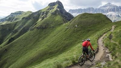
The starting point of the super tour to the Rasciesa Trail is Chiusa, just south of Bressanone. The first part of the route is unspectacular because you first have to climb up to Ortisei in Val Gardena. This is done on the cycle path to Waidbrück, then on small asphalt roads and finally a few meters on the main road to Ortisei. Here the Resciesa funicular railroad helps you over the last few meters up to the ridge. A wide trail now leads up to the Rifugio Resciesa. This section is used by many hikers, but the path is wide enough to pass without any problems. The culmination point of the tour is finally reached at the chapel and the long descent into the Isarco Valley can begin. And the first section is very rough. You fight your way down the first section over countless stone slabs. However, with sufficient suspension travel, wide tires and a cheeky riding style, the section is completely rideable. Finally, you reach a plateau, and now the tour changes character. It becomes flowy without end! Right from the point where the 7er trail branches off. You follow this first-class, flowing forest trail for several kilometers - one of the best trails far and wide. At a gravel road, you switch to the trail with the number 7B and continue in the same style towards the Gnolhof. Now the trail becomes faster and wider for a short while until it turns into a series of sharp hairpin bends further down. These are soon mastered, the flow continues, the village of Gufidaun is passed and finally the descent shines with a first-class final section down to the Schmelze industrial zone at the bottom of the valley. With a satisfied smile, you now head back to Klausen on the cycle path along the Eisack river.
Map & GPX-Track
The map is only available to Ride subscribers.
The Ride-Subscription is available at ride-mtb.com/abo
.
Details of the tour
42 km
1215 m
2000 m
1 day
Klausen
Klausen
1853
well suited
More information
No bike shops are registered for this region. Registration as a partner takes place here.
More tours nearby















User comments (9)

About the author: Thomas Giger
Note: This content has been automatically translated from German. Please report any incorrect translations.
Ridden on 31.07.2025, with enduro bikes, in partly wet conditions.
Overall a cool tour, with lots of downhill trails and a phenomenal start to the descent on the Steinweg. This section is very steep and seems a bit extreme, but the stones are quite smooth and getting stuck including 'over the bar' is rather unlikely (although not impossible). There are a few places where not too S3/bunny hop experienced riders are forced to dismount.
The trail afterwards is almost always very narrow, much riskier in the rain thanks to slippery stones and roots and unfortunately rather poorly maintained. Overgrown areas, barely recognizable hiking trails or numerous trees lying across the trail are unfortunately more common than desired. According to a local, we were lucky, as the trail was only cut back two weeks ago and must have been almost completely unrideable beforehand. Nevertheless, there were some very fast, flowy sections. And of course a lot of trail overall.
Rode a super cool tour today! Would only ride in dry weather!
The downhill run has been cut free of trees - it was almost perfect ;-) You could have cleaned up a bit more and gone through with the machete, but that's probably asking too much :-D
Heya zäma, does anyone know how the trail is rideable now in August, in terms of wood etc.? Thanks for a quick reply.
I would also be very interested - does anyone know anything?
Any news on the condition of the descent?
Attention! Trail currently not recommended due to numerous windthrows!
I can only confirm this. At least 60% of the trail is NOT rideable because there is simply too much material in it. Don't think the trail will be rideable again before the end of 2022, as much as there is. Trail looks promising without all the wood.
Route ridden at the end of June 2021: In the lower part after the Gnolhof, there is still a lot of fallen timber from last winter.